
Leapfrog Updates for Civil and Environmental: Faster and Smarter Ground Modeling
Seequent, The Bentley Subsurface Company, has unveiled a notable release of Leapfrog—its industry-leading 3D geological modelling tool—packed with extensive enhancements and faster workflows to improve productivity and decision-making.
Leapfrog 2025.1 delivers value to civil and environmental customers with advancements to Leapfrog Works’ structural workflows, saving users time creating and understanding structural trends—to help improve decision-making on projects from site characterisation to design optimisation and risk assessment. Enhancements to cross sections allow ground conditions to be communicated more simply and accurately with stakeholders and colleagues. Users can associate information, such as standardised classifications, with volumes, whether modelled as a geological model or an imported or extruded mesh.
Summary highlights for Leapfrog Works include:
- Refreshed structural trends for faster and smarter modelling with fewer manual edits
- Field mapping using polylines to streamline geological model updates
- Data preparation, visualisation, and analysis upgrades for survey, point and structural datasets
- Cross-section updates for improved communication with stakeholders and colleagues
- Multi-dimensional attribution unlocks new workflows
Dr Rachel Murtagh, Manager, Product Management – Geology, Geostatistics and Data Science, Seequent, says: “At Seequent, we are committed to empowering geoscience-driven industries to address critical challenges with greater efficiency and intelligence. As project complexity increases and economic and ESG pressures intensify, we continue to advance our solutions to meet evolving demands.
“This Leapfrog release introduces significant updates to the structural trend’s usability, visualisation and data handling, and cross section enhancements, to deliver immediate value to our civil and environmental customers.”
Enhanced Structural Workflows and Cross Sections:
Leapfrog 2025.1 updates to 3D modelling tool Leapfrog Works allows users to build and refine models even faster for civil engineering and environmental projects. Key feature and functionality updates include:
- Refreshed structural trends to enable faster modelling with fewer manual edits, saving users time in creating and understanding these trends. Structural trends are essential for making implicitly modelled surfaces and volumes geologically meaningful. This update provides a more comprehensive presentation of the structural trend. An updated interface introduces new controls for filtering input data and adjusting ‘clustering’ settings. Additionally, a new editable visual representation of the structural trend offers a more accurate and user-friendly depiction of the trend and can match the actual extents of the input data.


Images: (Top) Structural trend clustering in Leapfrog Works before adjusting parameters; and (bottom) after adjusting parameters to show a more continuous volume with fewer clusters, honouring the geological interpretation and the structural trend more closely.

Image: New options for structural trend visualisation allow a custom grid to inform the visualisation of the trend; display options include orientation information and strength
- Streamlined model updates with field mapping using polylines: To further enhance how surface mapping data is incorporated into the model, new data can be appended to a polyline to manage it as one polyline object in the Leapfrog project.
- Data preparation, visualisation, and analysis improvements: New import and share category colours for geoscience data have been added to standardise legend colouring quickly. A streamlined process for combining mixed data sources for point datasets (e.g. drilling intervals and points), and structural datasets avoids rework of numeric models.
- Communicate effectively with cross sections: Users now have the option to set an orthogonal or illustrative (formerly scaled) projection style on long sections, for datatypes including drillholes, planned drillholes and polylines. Illustrative projection is ideal for communicating with management and creating visual reports for non-technical audiences and orthogonal projection is ideal for sharing accurate data with contractors and technical stakeholders. Other improvements include applying query filters on the polyline to render only part of the line, and displaying positive or negative offset labels for holes on sections.

Image: Orthogonal and illustrative projection options on long sections assist cross section communication
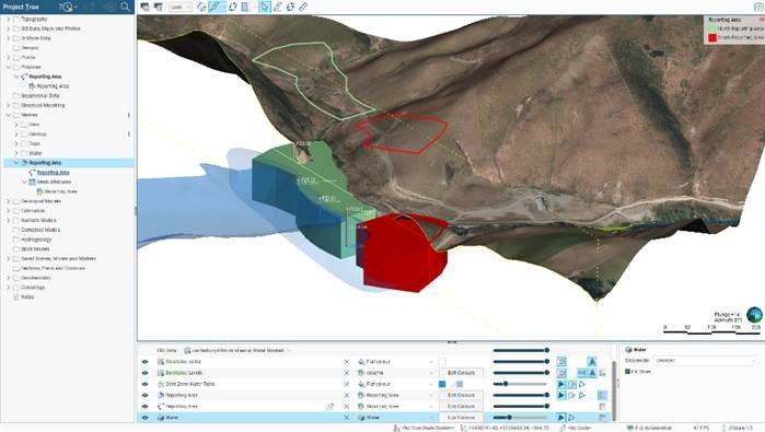
- Multi-dimensional attribution unlocks new workflows: Users can associate information, such as standardised classifications, with volumes, whether modelled as a geological model or an imported or extruded mesh. Attributed information flows from the polyline to the extruded mesh without additional effort. This improvement generates simple volumes from a single attributed polyline, a common requirement in ground works of many descriptions.

Image: Multi-dimensional attribution enables information to flow from the polyline to the extruded mesh to generate volumes to aid ground work workflows
For more information on Leapfrog updates, see:
Leapfrog Works: https://www.seequent.com/products-solutions/leapfrog-works/
