
World’s Largest Wildlife Crossing Nears Completion in Southern California
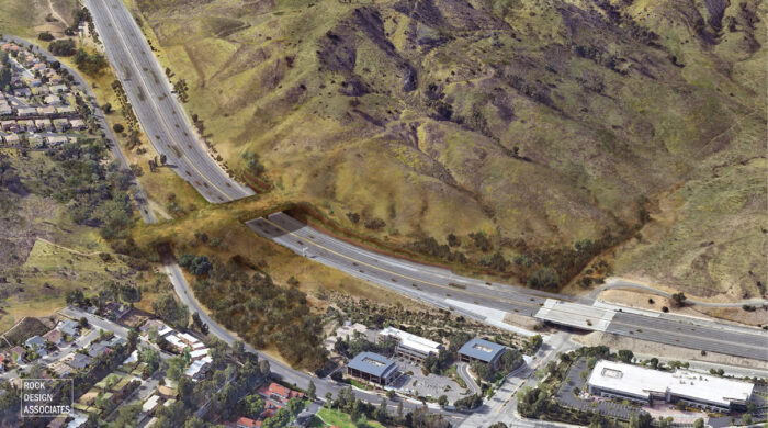
The Wallis Annenberg Wildlife Crossing will span U.S. Highway 101 to connect the Santa Monica Mountains along the Pacific Ocean with the Sierra Madre Range to the north. (Rock Design Associates and National Wildlife Federation)
The largest wildlife crossing in the world completed its first phase in June 2025, paving the way for restored ecosystem connectivity in the Los Angeles area. Sited among challenging terrain and over one of the busiest highways in the country, the Wallis Annenberg Wildlife Crossing will span 210 feet across U.S. Highway 101 in Agoura Hills, Calif., linking the Santa Monica Mountains and the Sierra Madre Range with a 174-foot-wide living bridge, roughly equivalent in width to six lanes of roadway.
Led by a team with representatives from the National Wildlife Federation (NWF), the California Department of Transportation (Caltrans), the National Park Service (NPS), the Santa Monica Mountains Conservancy and the Mountains Recreation & Conservation Authority, the project’s first phase involved construction of the vegetated superstructure. Its second and final stage—now underway and scheduled to complete at the end of 2026—includes the relocation of utility lines, earthwork and restoration of wildlife habitat adjacent to U.S. 101.
A Lion Makes a Life in Hollywood
The project owes much of its genesis to a mountain lion known as P-22, according to Beth Pratt, NWF executive director of the California regional center, which helped raise more than $87 million for the $92 million crossing. Project funding sources include the Annenberg Foundation, the California Wildlife Conservation Board, the Santa Monica Mountains Conservancy, the California State Coastal Conservancy and the State of California.
In 2012, camera traps spotted P-22 in LA’s Griffith Park, the public lands east of the famous Hollywood sign, confirming a mountain lion where one had never been verified before. He caught the attention of biologists when genetic testing traced his birthplace to the western Santa Monica Mountains, meaning he had crossed both Interstate 405 and U.S. 101 to get to Griffith. With each highway spanning more than 10 lanes of traffic in places, they typically act as barriers to wildlife movement.
P-22 did not cross them again. Instead, he spent the remaining 10 years of his life at Griffith, limited to an area of only eight square miles when mountain-lion territories typically span hundreds of square miles.
“He came to represent what these freeways and this lack of connectivity did to wild animals like him, and launched kind of a real movement,” says Pratt.
GPS tracking and occasional camera captures of the lion in LA’s backyard elevated P-22 to celebrity status, spawning news updates, documentaries and even his own fan-made magazines.
“He took a very scientific story and lifted it off the page and made it a very human story,” adds Pratt. “Cut off, the last of his kind—people in LA can relate to their lives being impacted by the 405 divide, which his was.”
A 25-year study of the area conducted by NPS biologists and collaborators identified U.S. 101 as a major barrier to wildlife movement and gene flow. Although the consequences of human-induced genetic isolation have impacted many of the area’s animals, ranging from bobcats to lizards and even a species of bird, mountain lions have borne the worst effects due to the large territory requirements, small population sizes and low reproductive rates typical of large predators. The mountain lion population in the Santa Monica Mountains exhibits the lowest genetic diversity in the western United States, already resulting in physical deformations.
“Their territories are limited by the freeways; they are shaped by them, and that is the whole problem here,” says Pratt. “Not only do these animals get hit by cars, but the greater problem is, and this is why the crossing’s so critical, is that the population south of 101 can’t get out, new blood can’t get in, and they are inbreeding themselves out of existence.”
A Challenging Site
The NPS’s work, combined with open-space preservation efforts by advocates such as the City of Agoura Hills and the Santa Monica Mountains Conservancy, pointed to a 1,600-foot bend along U.S. 101, the last stretch with public lands on both sides when heading southbound, as the best location for a wildlife crossing.
To add to the challenges presented by the curve, the 13-acre project site includes a 175-foot grade change from north to south, and the crossing must span utilities and Agoura Road in addition to the 10 lanes of freeway.
The team opted to use a combination of precast and cast-in-place elements largely to minimize construction-related closures of the freeway whose annual average daily traffic exceeds 300,000 vehicles per day, explains Robert Rock, president and CEO of planning and design firm Rock Design Associates, LLC. Rock Design worked in collaboration with Caltrans on the project’s planning, design and construction.

The 13-acre project site includes the smaller Agoura Road as well as the freeway.(Rock Design Associates and National Wildlife Federation)
Manufactured by Coreslab Structures, the bridge deck’s 82 precast, half-span girders measured roughly 4.5 feet square by 100 feet long and were trucked over to the site after casting from Perris, Calif.
Space limitations upon the girder shoring presented its own challenges as the shoring had to meet the lateral seismic and wind demands of Caltrans standards within the narrow space between the highway and the new abutment walls, resulting in falsework towers only 4 feet wide.
“The engineering that went into the temporary bridge shoring design was under the microscope as the heightened sensitivity for public safety was felt as the days edged closer to setting the girders and finally building the superstructure of the bridge,” says Jameson Schwab of D.H. Charles Engineering, Inc., which provided the shoring.

Soil from 1 to 4 feet atop the bridge deck will attempt to mimic the adjacent landscapes. (Rock Design Associates and National Wildlife Federation)
Construction closed the freeway overnight when traffic was at a minimum, placing three or four girders per night before reopening the freeway for the morning commute.
“Thinking about, ‘How can we be least disruptive when we need to place those elements?’ was a key part of that conversation,” says Rock. The project received only one traffic complaint during the month of nightly closures.
Although the combination of precast and cast-in-place elements created some unique complexities around how the different components such as rebar and joints knit together, the alternative of casting in place the entire structure would have also required additional space for the form work.
“On the south side of the structure down to where we meet at the creek on the other side of Agoura Road, it’s about 80 feet of grade change. So, any additional elevation creates complexity,” notes Rock. Building the deck with precast girders allowed the team to keep the structure several feet closer to the freeway. The combination also gave the project a certain efficiency of construction, allowing the team to build both the bridge abutments and box girders simultaneously.
Dirt, Plants and Water
Rock said the biggest difference between designing Annenberg vs. a more-conventional bridge was a shift in what constituted the dynamic live load of the structure. Whereas other bridges carry vehicles and people, Annenberg’s plants, animals and water presented different requirements, causing the team to reevaluate certain ideas such as water retention.
“Thinking about how water interacts with structures is one of those hallmarks for structural engineering,” says Rock. “It’s a cardinal sin to hold water on top of the structure. When you’ve got essentially a giant green roof perched on top of this massive structure, there’s a thoughtful process into not just the structural principles to support that dead load, but also thinking about saturation of that soil and vegetative layer, and how does that change the dynamics you have to evaluate when you’re looking at it through that structural lens.”
The soil profile varies from 1 to 4 feet thick, which the team’s mycologist helped design to mimic a surface horizon, subsoil and substratum. Because the deck pitches at two percent to the north, the deck itself has positive drainage, but below the soil’s three major horizons sits what Rock referred to as a “porous mattress,” a drainage layer of pea gravel embedded with perforated pipes every 10 to 12 feet across the deck.
The pipes collect into a manifold at the crossing’s north side, which currently feeds directly into the storm sewer. The project’s second-stage plans involve severing that manifold to allow the water to drain back into the immediate landscape, creating a new ephemeral creek and restoring the natural drainage lost when that section of freeway was widened.
Mitigation Features
Wildlife users also differ from their human counterparts in how they react to sound and light, a major consideration for a project aimed to invite animals to cross under the cover of darkness, when many animals typically travel. The structure’s light mitigation includes a pigment mixed into the concrete that gives it a dusty mocha color similar to the color of the soil and terrain adjacent to the site.
“We were attempting to reduce the surface-reflectivity index of the material so we didn’t have as much light bouncing off it, creating sky glow by hitting all the particles in the atmosphere, creating an artificial haze for those nocturnal species,” notes Rock.
The team took extra steps to color match the precast concrete with the cast-in-place elements. The pigment also altered variables such as the concrete’s unit weights, which the calculations had to account for.
Based on research studying the impact of color temperature on wildlife, the project adjusted the color of the corridor’s light fixtures from the 4,000 K or 5,000 K typical of highway lighting to between 1,600 K and 1,700 K—more of an amber hue instead of blue-white.
“That doesn’t change the safety of the roadway because you still have the same level of foot candles along the roadway,” explains Rock. “It’s still the same level of illumination. But you’re changing the color of it as it relates to how that’s going to end up impacting the wildlife moving through.”
The fixtures also include shielding to direct the light at the roadway and not at the surrounding habitats.

The project’s light mitigation will include lower color temperatures and pigmented concrete designed to match the
surrounding soil. (Rock Design Associates and National Wildlife Federation)
Conventional concrete sound walls placed between roadways and residential areas typically reduce sound intensity by between 10 and 15 decibels. With noises in the 90 to 95 decibel range at Annenberg’s section of freeway, emitted mainly from tire friction, animals would still hear noises behind such a barrier at the level of common household appliances such as garbage disposals or window air conditioners. Conventional sound walls also attenuate the sound frequencies most sensitive to humans, which are higher than the frequencies smaller species pay attention to.
The design team therefore opted to mitigate sound in a different way, creating large, earthen barriers along the freeway. In addition to blocking more low-frequency sounds, the use of onsite materials proved more cost effective.
“Instead of coming in with more concrete, we’re using soil, and we’re using geosynthetic reinforcement to lock all that stuff together,” says Rock. “There’s a cost efficiency to that. There’s a kind of methodological efficiency, too, by using the materials that are there onsite.”
The Complexities of Southern California Water
The crossing broke ground in the middle of 2022 but faced two consecutive years of abnormally high rainfall that added about a year to the project schedule for the site to dry out.
“That hit at the exact wrong time,” notes Pratt. “It’s when they were pouring concrete for these vast supports and also trying to pack the soil.”
The area’s water also caused the design to use a more costly and complicated system for its foundation. The project site’s unique hydrology, which includes an unusually high water table in addition to the intense downpours from atmospheric rivers becoming more common in California, has resulted in an ephemeral creek on the south side of the project that still runs as an underground creek during the dry season. As a result, the team elected to use cast-in-drilled hole piles for its foundation system instead of spread footings.
The Crossing’s Legacy
Philanthropist Wallis Annenberg, along with her philanthropic nonprofit the Annenberg Foundation, championed the crossing project with millions of dollars of challenge grants. She passed away in July at the age of 86, soon after completion of the first phase.
“There’s a reason I wanted to support this crossing and issue this challenge: We need to move beyond mere conservation toward a kind of environmental rejuvenation,” Annenberg said in a statement through the foundation. “Wildlife crossings are powerfully effective at doing just that—restoring ecosystems that have been fractured and disrupted. It’s a way of saying ‘there are solutions to our deepest ecological challenges,’ and this is the kind of fresh new thinking that will get us there.” 
About David Jen
David Jen is a freelance science journalist based in the San Francisco Bay Area. Learn more about him at www.davidjen.com or follow him on Twitter @djenwrites.
