
Raising Charleston’s Low Battery Seawall to Stem the Tide of Rising Sea Levels
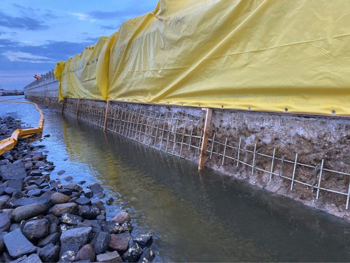
A photo shows in-progress construction to raise the height of the Low Battery seawall in Charleston, S.C., by approximately 2 feet with options to extend the front part of the wall even higher to better accommodate the U.S. Army Corps’ vulnerability study of sea level in the area.
A $64 million seawall improvement project in Charleston, S.C., has been designed and constructed to provide a line of defense against rising sea levels.
According to the NASA Sea Level Change Portal—which provides detailed data, visualizations and research on sea-level change, including its causes and impacts—global sea levels have been rising for decades in response to a warming climate. The annual rate of rise has increased from 0.08 inches a year in 1993 to the current yearly rate of 0.17 inches a year—more than double.
Since Charleston’s founding in 1670, the city’s growth and prosperity has been fueled by the port and maritime industry, which takes advantage of the deep harbor and proximity to the open ocean, notes Jim O’Connor, P.E., South Carolina operations manager for consulting firm Johnson, Mirmiran and Thompson (JMT).
“Like many coastal cities at the time, Charleston backfilled or removed marshes and creeks to create usable land around the downtown on the peninsula,” explains O’Connor. “Although this was a standard practice of urban design in the early 1900s, we now know how problematic this is from a water-management perspective.
“The city has been plagued with drainage and flooding issues due to its near-sea-level elevation,” he adds. “This has left the city vulnerable to extreme weather and sea-level rise, which made it imperative to take action to update and improve the Low Battery seawall as a first line of defense for the Charleston peninsula.”
The Battery is a seawall on Charleston’s southern peninsula that overlooks Charleston Harbor, where the High Battery and Low Battery seawalls merge. The Low Battery was constructed as part of a large land-reclamation project undertaken in two phases: The first section (1909-1911) extended from Tradd Street to King Street. The second phase (1917-1919) extended from King Street to the “Turn” at the intersection with East Battery Street. The concrete wall of the Low Battery was constructed on a timber deck supported by timber pilings.
The Low Battery seawall was in a state of advanced deterioration—evident through large cracks, crumbling concrete, exposed rebar and eroded base—raising concerns for its effective remaining service life.
Through the years, Charleston has become one of the fastest-growing areas in the country due to its coastal location, quality of life and rich culture. “People continue to move to this area, which is also spurring development both in the city and surrounding areas,” says O’Connor.
Like many coastal cities, Charleston’s ongoing development has led to increased flooding issues as water has few places to travel through impermeable surfaces. Sustainable solutions have become a favorable approach to mitigating this problem.
In discussions around reconstructing the wall, the city adopted a sea-level-rise strategy that included new infrastructure being built to higher elevation. A Seawall Evaluation and Study prepared by Cummings and McCrady evaluated the condition of the Low Battery wall in 2004 and presented potential repair methods as well as an estimate of probable cost. In May 2015, JMT began the surveying work necessary to accurately collect data needed for the assessment and design of the seawall.
A new city initiative was introduced during the design phase, requiring new city projects with a design life of 50-plus years to account for an anticipated sea-level rise of 2.5 feet. This requirement, along with the need to reconstruct the sidewalk to meet the Americans with Disabilities Act guidelines for accessibility, led to changes in the design approach.


Photos show construction from the 1900s (top) of the original Low Battery seawall in Charleston, S.C.; in-progress construction (middle) of the Low Battery seawall, which stretches approximately 5,800 feet along the tip of the Charleston Peninsula; and a completed section (bottom) that includes road and drainage improvements to better protect the city against major storms and higher tidal events for the next 100 years. The improvements also provide increased public waterfront space and enhancements to the promenade.
While the project was in design development, the U.S. Army Corps of Engineers (USACE) embarked on a separate study for peninsula flood protection. The Charleston Peninsula Coastal Storm Risk Management Study is a federal study investigating coastal storm impacts on the Charleston peninsula and, in partnership with the City of Charleston and its stakeholders, is developing effective, economically viable, and environmentally sound solutions to mitigate risks and build enduring coastal storm resiliency.
This four-year feasibility study began in 2018 and concluded with a final detailed report to Congress in summer 2022. The final top elevation of the Low Battery wall was set to coincide with the Corp’s recommended elevation so the city’s wall could be integrated into the final USACE solution.
While the original goal was to increase the wall height by 2 feet to an elevation of 9.5 feet, the wall was designed to accommodate the USACE vulnerability study, which would raise the wall—filling in the open railings—an additional 1.5 feet.

crumbling section of the old Low Battery Seawall showcases the urgent need for updates.
Modern Technology to Help Solve an Old Problem
To redevelop Charleston’s Low Battery Seawall, JMT employed Autodesk’s InfoDrainage to optimize the stormwater drainage design.
Ryan Mattie, P.E., Charleston, S.C., office leader at JMT, recommends implementing cloud-based, modern technology from the beginning of the project-planning process to accurately understand the impact of extreme weather and flooding on project sites, especially for civil engineers whose work entails tackling climate-change concerns and best presenting those solutions to stakeholders such as elected officials and the public.
“This is the most-efficient way to inform your designs and ensure that projects are resilient and can last for decades into the future,” he adds. “Autodesk InfoDrainage modeled the impacts of flooding, and this information directed our designs of the city’s drainage system.”
Autodesk Civil 3D was the firm’s core design tool for raising the Low Battery seawall to the proper height to improve the capacity of its storm drain systems. “Technology was critical in our process to design and make the improved Low Battery seawall better able to protect the Charleston community,” says Mattie.
InfoDrainage modeling software was chosen for the Low Battery project because it has the capability to connect directly with JMT’s Civil 3D design files for an easier design workflow.
JMT depends on a custom library of parts inside Civil 3D, including customized South Carolina Department of Transportation and city structures, so its drainage-design software needs to integrate with Civil 3D as seamlessly as possible to avoid rework and reformatting.
“The software also allowed us to compare existing and proposed condition design phases in one file, model the storm drain design under multiple boundary conditions, and produce a surface-flow scenario to check surcharged stormwater impacts,” adds Mattie.
JMT’s hydraulic design team incorporated NOAA ATLAS 14 and local rainfall data into InfoDrainage models with a built-in rainfall distribution tool, using it with an increased 10 percent safety factor to develop accurate and safe stormwater models to meet the project’s specifications.
Design Details
According to JMT, increased rainfall and higher tailwater conditions on the wall were two main hydrologic factors affecting its drainage system, leading to designing a system of drainage pipes and valves to address sea-level rise and create resilient infrastructure for the city.
Using InfoDrainage’s built-in HEC-22 sizing tools for inlet-specific features, JMT determined drainage spread, using the model to create preliminary pipe-sizing estimates. InfoDrainage helped the JMT team to clearly visualize water flow and conditions and share this work with other stakeholders. The solution evaluated the site’s drainage conditions between its two high-tidal cycles, which in combination with heavy rain events lead to most of Charleston’s drainage issues, says Brian Deeley, Autodesk director of product management, water solutions.
“The team used this information to design an advanced system of drainage pipes and valves that mitigates sea-level rise and provides more-resilient infrastructure for Charleston,” he adds.
JMT also used the Autodesk Civil 3D and InfoDrainage integration to support collaboration and project planning with precision. “This technology enabled JMT to rebuild the Low Battery seawall to protect Charleston from the impacts of extreme weather and sea-level rise for years to come,” notes Deeley.
“The two programs were able to easily transfer design-related information between one another, making it a seamless process to export results into Civil 3D for the final plan production,” explains Mattie. “With the threat of rising sea levels and increased frequency of major storm events, coastal cities such as Charleston have limited options to work with when it comes to keeping water out.”
According to Mattie, seawalls and bulkheads have been a proven means to keep tides and storms at bay. “However, they do come with challenges,” he adds. “While walls are great at keeping water from coming in, they are a hinderance to rainwater getting out.”
Often, a pump station will need to be constructed to fix this issue, as has been the case in many areas around the Charleston peninsula.
Although no pump station has been planned for the near future at the Low Battery, designing the new drainage system to include tidal valves helps prevent tidal influence and modest storm surges from encroaching into the city’s drainage network and creating surcharge conditions.
However, during certain high-tide events or when a storm is happening and water elevations rise above the system, the valves are in the closed position, which impedes water from leaving the city’s system.
“The city is currently working with the USACE, developing a solution to extend the new battery wall or some version of it along much of the Charleston peninsula to provide a higher elevation of protection for the entire peninsula,” says Mattie.

Consulting firm JMT leveraged Autodesk InfoDrainage software to improve the Low Battery seawall in Charleston, S.C., which will help protect the community from the impacts of extreme weather and future flooding.
Environmental Impacts
One of the main challenges with the project as it relates to managing water and the tides while minimizing impacts to the environment was how to construct the new wall in place of the existing wall without encroaching into the adjacent wetland/river, whether temporary or permanent.
“The design employed a very surgical methodology to demolish the upper portion of the existing wall close to the high-tide line; maintain the lower portions of the wall; core through the wall to install micropiles, replacing the old timber foundations; and then reconstruct the upper portion of the wall to the new elevation and promenade width,” says Mattie.
To accomplish this while managing the daily tide swing, the contractor installed a series of wall forms, which also doubled as flood protection from higher tides until the proposed higher wall could be constructed.
Stormwater avenues coming from the land side via the existing drainage networks also needed to be maintained throughout the project. This, combined with higher water tables, required the contractor to install temporary underdrains and pumps to keep the site dry during construction.
“This was key to the installation of large water-quality structures placed strategically throughout the corridor,” explains Mattie. “Several new outfalls were also installed along the new wall face, and existing outfalls were rehabilitated, with each getting a new tidal check valve to prevent tidal and storm-surge flooding.”
Although the battery reconstruction project didn’t reduce impermeable surfaces throughout the corridor, it did provide improved drainage infrastructure and several new outfall locations to better manage existing and future conditions, explains O’Connor.
“The increased capacity of the system helped the immediate areas adjacent to the project while the new outfalls—with tidal check valves—provided derivative flooding relief for upstream areas of the peninsula whose stormwater makes its way to and through the Low Battery Wall,” he adds.
In addition, water-quality units were installed during this project to help protect the aquatic life in the Ashley River, which already has poor water quality.
O’Connor notes the wall should last the typical 75 years traditionally planned for major infrastructure works, but considering the design incorporated resilient elements such as GFRP (fiberglass reinforcement) in lieu of traditional steel for reinforcement, his firm is hopeful the wall will stand at least another 100 years or more as the city’s first defense to rising sea level.
About Carol Brzozowski
Carol Brzozowski is a freelance journalist specializing in technology, resource management and construction topics; email: brzozowski.carol@gmail.com.
