
Unlocking AI’s Potential to Advance Data Capture: The Role of Partnerships and Pilots
Pilots are an essential tool for uncovering the true value of a use case, providing a low-risk environment to test new technologies or workflows before committing to full-scale implementation. By running a pilot, organizations can validate assumptions, identify potential challenges and gauge the effectiveness of a solution in real-world conditions. This hands-on approach allows businesses to gather valuable insights, refine processes and measure tangible outcomes, ensuring that any investment in scaling the solution is backed by solid evidence of its impact. In short, pilots offer the opportunity to move from theoretical potential to demonstrated value, giving teams the confidence to proceed with larger, more-comprehensive changes.
By partnering across engineering firms, industry experts and hardware/software vendors, asset owners can tackle complex challenges, driving transformative results for their operations and customers. Asset owners, often hesitant to change workflows, do have an appetite to test new workflows and prove value. Such collaborations foster continuous learning, enhancing sustainability, reliability and cost-efficiency.
Modernizing Data Capture
Beginning as a university proof of concept, the Looq AI platform, a hand-held photogrammetric camera, exemplifies this model of partnership-driven innovation. While photogrammetry makes continuous capture more appealing, the level of accuracy many require was once only possible with LiDAR surveys, which can still create a hefty price tag. By working closely with research organizations, utilities and engineering firms, Looq AI has evolved into a powerful AI-enabled asset-capture solution that reduces time and costs compared to traditional surveys.
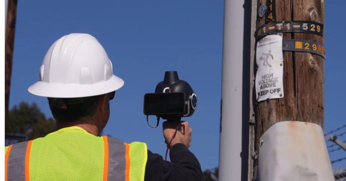
EPRI’s Incubatenergy Labs (IEL) program matches early stage technology companies with electric utilities in pilot projects demonstrating new technologies and products that address critical industry needs. Through this, Looq AI partnered with Central Hudson Gas and Electric to run an accelerated demonstration project to rapidly capture, create and analyze 3D digital twins of circuits consisting of several distribution poles and substations. The hypothesis is that a hand-held geometrically and geospatially accurate camera can supplement and, in some cases, replace LiDAR. While this research is ongoing, the pilot continues to prove that highly detailed and accurate data can be captured quickly and at much lower cost compared to other capture workflows.
Engineering firms, traditionally responsible for the design and implementation of infrastructure projects, now find themselves in a role that transcends conventional boundaries. By collaborating closely with utilities and vendors, they develop and refine technologies that not only meet current demands but also anticipate future needs. Utilities rely on the engineering ecosystem to leverage their expertise and resources for planning, designing and executing infrastructure projects, ensuring that these initiatives meet standards for safety, efficiency and regulatory compliance.

Users interact with digital twins, enhancing project collaboration and streamlining decision-making processes with a user-friendly dashboard for viewing, analyzing, tracking and handoff. ((Image courtesy of Looq AI and data from Central Hudson Gas and Electric.)
A notable example of this is Aquawolf, a wholly owned subsidiary of Mammoth Energy Partners LLC, which has a mission to provide exceptional stewardship of utility project budgets by employing innovative, cost-effective methods to capture existing conditions. To best serve its clients, Aquawolf has been implementing new processes with the help of Looq AI.
Aquawolf manages multiple types and aspects of projects, including preliminary electric transmission and distribution line routing; natural-gas pipeline conceptual design; detailed transmission and distribution line design; pipeline design; and construction support. Many of the projects they manage are resource and time intensive and often require working with 3D data. Their new AI-driven workflow is demonstrating how advanced capture technology enhances data-collection efficiency while maintaining the accuracy required. And they are proving they can cut costs by a third, reducing redundant data collection and enabling faster, safer project completion.

Close-range photogrammetry (CRP) with a terrestrial handheld unit (left) is supported by sophisticated AI algorithms, providing superior spatial resolution and rapid data processing as well as visualization and analysis via a web app environment (below). (Looq A)

On any project, the team can walk around and capture while they evaluate the site. Everything humans see, the camera can see as well. This new capture process eliminates the need for data to be collected by both surveyors and field technicians, and it can minimize the use of civil tools for thinning the data.
“Survey firms will bid on an entire package. We no longer need to do this,” says Alex Richards, P.E., president of Aquawolf. “Instead, we walk every mile of an overhead project with the hand-held camera. We are developing the digital twin while onsite and in one trip as opposed to multiple trips.”
Their teams often work with rough terrain dense with vegetation, and the alignments are in the trees. The original surveys will have gaps in topography and features because they are both obscured.
“With boots on the ground, we got into locations the survey could not. We got under the tree covers and could see through all the obstacles,” says Blake Darling, P.E., PMP, director of engineering underground programs at Aquawolf. “Filling these gaps surgically with the Looq AI platform means we deliver a better product and with 30 percent cost savings in the amount of data that need to be processed. This has been a key component of helping Aquawolf maintain its reputation for agility and high-quality engineering and design.”
With this new workflow, Aquawolf can focus on more valuable work vs. wasting time aggregating terabytes of unnecessary data. And this approach means fewer truck rolls and crews engaging with energized assets, working in rough terrain or dodging vehicle traffic. The benefits of this improved process include optimized resources, lower costs and improved safety.


Detailed maps capturing topographical features and existing infrastructure enable optimal positioning of charging stations, effective drainage designs and integration of electrical systems while ensuring compliance with regulations. (Looq A)
Aquawolf is providing engineering and design services on a large western utility for a 10-year program to underground all high-risk electric distribution circuits in the backcountry where there is high wind, fire and other threats to the overhead equipment. Due to the program’s scale, the utility sent surveys to collect data way before the design. But the survey didn’t cover 100 percent of the area needed.
Aquawolf decided to implement its new capture workflow, allowing it to capture rich data easily and rapidly beyond what they would normally get from traditional land surveys. Aquawolf was able to collect a significant amount of data without needing to know exactly which data points would be relevant when they began designing.
In a traditional process, they would have first figured out what they needed and then requested specific surveys, requiring detailed explanations to the surveyor. Often there’s a lot of back-and-forth communication happening, because someone forgets specific features or needs to expand the survey area—all of this can be time consuming and expensive.

Aquawolf captures data quickly for a client using a multi-camera system with a survey-grade GPS and an AI processor, enabling capture of detailed field data quickly and effortlessly as well as allowing them to quickly respond to a scope change and collect vital field data to keep the project moving forward. Alex Richards (above) quickly captures utility poles, and Todd Williams (below) scans a winding private driveway in a dense chaparral that was added to the scope from the original client survey.
“With the Looq AI platform, we capture everything we see while walking the site, and all of that becomes the digital twin,” says Darling. “Even the first couple of times we used the technology, we had this intuition that we were approaching survey accuracy and could supplement the traditional survey process at one-third the cost of traditional land survey.”
Aquawolf can ask a survey to establish a control network, then they verify the points in their scan to match what the surveyors found, tightening up the accuracy at a fraction of the original cost. When the captured data hit the cloud, there’s an advanced algorithm working to craft a high-precision, georeferenced 3D digital twin and 2D images that can be used to perform asset analysis.
“The real magic is the AI-enabled software,” says Richards. “We can automate 3D modeling and seamlessly interact with digital twins, enhancing the collaboration with our client and helping to streamline their decisions. This all happens in a dashboard where everyone can view, analyze, track and handoff the project.”
Working more collaboratively with utility clients is much simpler, because everyone can view, interact and collaborate on survey-grade 3D models within the data portal.
Aquawolf sees opportunities to improve workflows across topographic mapping and other utilities projects. For instance, utility overhead distribution upgrades are smaller in scale than a highway crossing or road widening, requiring updates only to a few spans. Typically, utilities don’t want to wait or pay for traditional LiDAR, because they don’t need the entire line point-to-point. Aquawolf will collect the required area much faster and create an accurate 3D model from that data, which can be quickly incorporated into more-powerful modeling software, providing an accurate representation of current conditions.

The technology workflow can capture and deliver all necessary data to support structural analysis. (Looq A)
Aquawolf can provide supplemental data for overhead transmission design by capturing wires and structures for modeling. Their new process allows for rapid capture of specific poles or spans, seamlessly integrating these into existing LiDAR datasets, thus expediting data updates for utilities. Traditionally, requesting a LiDAR vendor go back and collect this could delay data updates by several months.
When communications companies want fiberoptic attachments to utility poles, they must take measurements and provide this information in their request. Using the Looq AI platform, the team at Aquawolf can quickly capture and deliver the necessary data, including measurements and proof of clearance. And when needed, they can provide a 3D model to support simulation and analysis such as pole loading.
Needing Accurate Basemaps
Accurate basemaps are essential for the precise planning and efficient execution of electric vehicle (EV) charging parking lots. “This new process allows us to make necessary adjustments, such as safety and accessibility requirements, without additional site visits,” says Darling.
It also facilitates quick design changes based on client feedback. For instance, a client needed EV charging for seven additional buses on the other side of the lot; they adapted quickly using the digital twin. They can quickly see the impact of their design choices because they have the full surface built out from the scan. The team can quickly make grade adjustments to the designs without sending another crew out to rescan the area.


Processing produces an orthomosaic image and ground elevation information that can be brought into common CAD platforms for virtual walkthroughs. (Looq A)
“We have this incredible flexibility, and the time to capture these parking lots is measured in minutes vs. days for capture and vs. weeks for data processing,” adds Darling. “A basemap typically costs about $35,000, but with our new workflow, we can reduce expenses and enhance quality.” This innovative process is especially advantageous in restricted airspace areas, offering a superior alternative to traditional land-based surveys.
Seventeen states have implemented natural-gas master meter programs to regulate and ensure the safety of small pipeline systems distributing gas within specific areas such as mobile home parks, apartment complexes or housing projects. These programs require system owners to maintain operations and maintenance plans, records and maps, ensuring compliance with federal and state regulations. Many RV parks and similar entities lack the expertise to meet these new requirements. They rely on consultants, engineering service providers or utilities to manage their systems. Quarterly maintenance typically includes checking for odorants, inspecting valves, conducting leak-mitigation surveys and submitting records to site owners. These records then are forwarded to state authorities and reported to Pipeline and Hazardous Materials Safety Administration (PHMSA) to ensure compliance.
To help such small systems operators, Aquawolf will deploy its innovative capture workflow to expedite the restoration. This will help their clients save time and money, mitigate the risk of getting de-energized, and pass state inspections efficiently. A mobile home park in New Mexico, plagued by persistent leaks in its aging PVC natural gas system, was deemed too dangerous by the gas company and shut down. Aquawolf stepped in to provide engineering services for a complete system replacement.
![]()
![]()
After captured data are uploaded to the cloud, a proprietary and fundamental image-to-model (photogrammetry) algorithm runs a complex analysis to automatically construct a high-precision, sub-centimeter and georeferenced intelligent 3D digital twin as well as 2D composite images from the field data. (Looq A)
“In a short and simple process, we gathered comprehensive field data to ensure nothing was missed,” says Darling. “Even if I do not recall every detail, the camera with its advanced lenses on four sides captured everything, allowing us to rapidly create an accurate basemap. If additional data are needed, it’s a quick capture rather than a complex survey.”
Traditionally, such projects are time-consuming, involving manual surveying and extensive data processing. Yet during one site visit, Aquawolf created a digital twin of the entire 62-acre park with 230 coaches.
From Pilot to Implementation
Transforming the proof of value from a pilot into a scalable workflow ensures that the insights gained during testing can be effectively applied across the organization, driving long-term impact and optimizing operational efficiencies. However, it’s common for pilots to never go beyond the test.
It’s important for the proof of value to be validated, with clear, measurable results that demonstrate its success and learnings. This includes securing buy-in from key stakeholders, aligning everyone on objectives, resources and expectations for the broader rollout. Additionally, it’s important to assess the scalability of the underlying infrastructure, ensuring it can support the expanded deployment without compromising performance.
By engaging in regular, structured dialog about new features, integrations and enhancements, stakeholders can effectively tailor software tools to enhance utility infrastructure management and address emerging industry challenges. The objective of the Aquawolf partnership with technology vendor Looq AI is to help them align the hardware and software evolution to needs of their clients and the services and value they want to deliver.
“While the qCAM is a simple piece of hardware, the software has almost limitless possibilities for the future,” adds Richards. “The Looq AI team has been receptive and innovative in the types of data tools they deploy on a regular basis: automation of point processing, point-cloud classifications and the ability to manipulate this inside the user interface. We continue to have conversations about the next improvements.”
A solid change-management strategy also is vital, as it helps address any resistance and ensures smooth adoption across teams through training, communication and ongoing support. Finally, establishing feedback loops for continuous monitoring and risk-mitigation strategies is essential to adjust and prevent disruptions during the scale-up, helping ensure the new workflow can be successfully integrated into the organization.
Collaborative feedback is pivotal for driving continuous improvement and ensuring the relevance of technological solutions in the utility sector.
“Our team is dedicated to delivering innovative solutions that provide immediate, tangible value to our clients,” says Dominique Meyer, PhD., CEO at Looq AI. “We regularly engage with our clients through structured feedback sessions and continual dialog to guide our product updates and roadmap. This ensures our technology not only meets but exceeds their evolving needs.”
This proactive approach to development and integration helps ensure that the solutions provide immediate value.
Editor’s Note: To learn more about Looq AI, listen to this podcast interview with CEO Dominique Meyer, PhD.
About Teresa Elliott
Teresa Elliott is a freelance writer and industry thought leader with 20-plus years of experience in B2B software and services for AECO/infrastructure; email: telliott.jbtv@gmail.com.
