
Location Intelligence Helps Commercial Building Developers Work Smarter, Not Harder
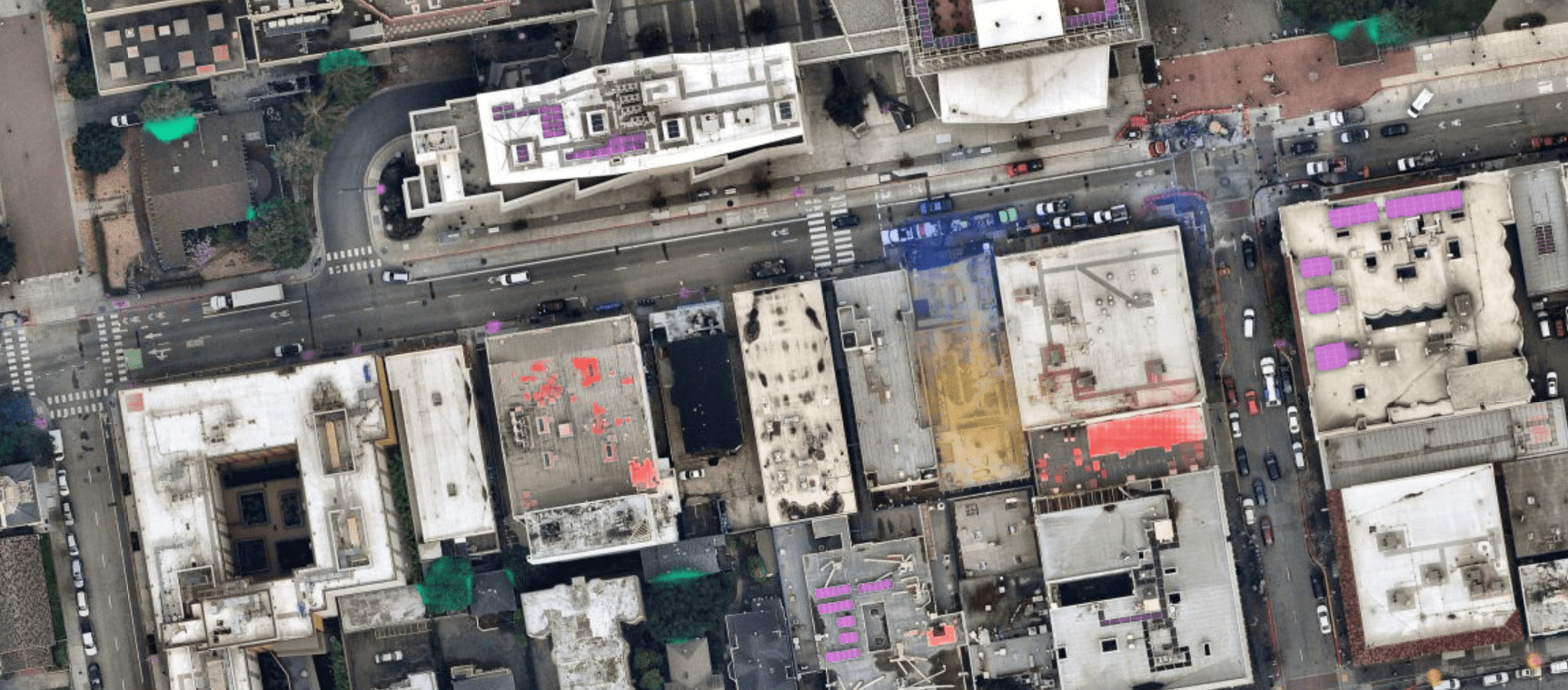
Developers can access maps with layers featuring key datasets such as tree overhangs (green), solar panels (purple), buildings under construction (yellow), construction sites (blue) and roofs with permanent repair (red). (Image credit: Nearmap)
With the volume of development projects for new skyscrapers, stadiums, strip malls and office buildings on track to return to pre-pandemic levels, AEC firms need the proper technologies to gain efficiency and provide decision support throughout a project lifecycle. Location intelligence and supporting technological advancements are becoming indispensable solutions in this endeavor.
Location intelligence leverages aerial imagery, photogrammetry, geospatial data and AI attributes to supply commercial developers with nearly anything they need to know about a project. As environmentally friendly, responsive, “smart” buildings become increasingly important and attractive to build, location intelligence technology enables a streamlined construction process and encourages further development. Ultimately, the true value of location intelligence—and its ongoing, rapid advancements—is its ability to fuel faster and more-accurate decisions, paving the way for a future of sustainable, interconnected communities.
Shaping the Commercial Landscape
The commercial sector continues to recover from a rocky 2023, characterized as a year of instability due to inflation and economic issues. Nevertheless, as they say, crisis brings opportunity.

AI layers can show developers existing solar panels (purple) and any areas with vegetation, typically trees, above a roof or building that provides sources of shade (green). (Image credit: Nearmap)
Amid disruption in the commercial space, location intelligence is helping developers gain a clear view of opportunities through accurate and actionable data, enabling them to make more-informed decisions in every phase of planning and development.
For example, by evaluating geospatial data against project objectives, today’s developers can accurately assess the accessibility and vulnerabilities of a construction site before they break ground. Location intelligence allows the site and its surrounding areas to be viewed from all angles and for these views to be shared as project context with all involved. Access to comprehensive location data leads to better planning and communication for shorter project timelines, lower construction costs and peak profitability. Simply put, location intelligence and related tools translate to more-informed site selection and design decisions as developers tailor new and existing sites for maximum efficiency while navigating potential risks.
Aiding the Planning and Development Process
Location data, aerial imagery technology and other digital tools are converging to provide developers and local-government officials with a wealth of accurate and clearly visualized data. Up-to-date, high-resolution aerial images can be overlaid on maps with layers featuring key datasets. Data visualization helps developers gain land, demographic and municipality insights critical to know before breaking ground, so they can proceed with efficient construction projects that anticipate and avoid costly and time-consuming challenges.
Commercial building projects begin with site selection, requiring developers to consider potential risks associated with the location, including environmental, existing site and infrastructure damage, and more. These maps can be layered with municipal data providing insight into zoning laws, parking and other transportation-related information. Terrain data can be added to model water pooling and flood potential to inform drainage design. As builders and building managers continue navigating workforce shifts, location intelligence is a competitive advantage for understanding population trends and, therefore, where they should prioritize developments. This can help builders and developers gain the trust of stakeholders at a time when budgets are tight and confidence is key.
In this way, location intelligence fuels plans that move past constructing a building to strategically leveraging its location to optimize operations, attract ideal tenants and achieve commercial success. Aerial imagery and location intelligence grant developers a comprehensive view of traffic patterns and nearby competitor offerings. When combined with demographic data from other sources, location intelligence can contribute to a deeper understanding of the wants, needs and historical behaviors of the local market. From here, developers can determine the profitability of a construction project in a particular space. This helps them pinpoint areas of opportunity, informing smart decisions about the building’s unique value proposition.
From these insights, developers can uncover opportunities and anticipate challenges to create a detailed plan to move forward with confidence and exceptional efficiency. In addition to solidifying a vision, location intelligence can shorten project timelines and improve cost savings. For example, remote access to real-time, 3D location data allows developers to reduce costly and time-consuming trips to the project site.

An image of Mercedes-Benz Stadium in Atlanta shows road overlays and bus stations. (Image credit: Nearmap)
And then, when it comes time to build, location intelligence supports construction optimization. Location intelligence technology provides all involved with shareable, easy-to-digest information. Detailed data visualization and modeling make plans simple to share with stakeholders, so they can weigh in on construction and design. This helps eliminate communication bottlenecks that can prolong construction timelines and increase costs.
Further, indepth depictions of spatial data and the landscape surrounding the construction site can help developers anticipate onsite conditions, so they can allocate appropriate materials, personnel and resources for optimal workflows. Expanding access to location intelligence is ushering in a new approach to commercial development poised to reshape localities and the industry landscape. Ripples from the current wave of data-based commercial-development decisions will be felt in society at large, as the next generation lives and works in spaces that adjust to meet individual needs and environmental imperatives.
Creating ‘Smart’ Buildings and Communities
In addition to economic turbulence, the commercial industry is facing mounting pressure from governments, investors and the public to build commercial facilities that are more energy efficient and support new ways of working. Aerial imagery technology, AI and other tools are helping developers seize opportunities to construct so-called “smart” buildings that adjust their environment and energy usage in accordance with data on internal conditions.
Aligning operations to data insights can help smart buildings conserve key resources, including energy expended on heating, ventilation and air conditioning (HVAC) and electricity. Compared to traditional buildings, smart buildings can reduce energy consumption by 30 to 40 percent, reduce water consumption by 20 to 30 percent, and reduce carbon dioxide emissions by up to 35 percent. Estimated at $96.96 billion in 2023, the value of the smart building market size is expected to quadruple to reach $408.21 billion by 2030. The rise of smart buildings is accelerated by growing adoption of AI, aerial imagery and a closer focus on location intelligence.
During a smart building’s development, location intelligence can be used to generate optimized site plans, engineering designs and smart summaries for drone surveys, among other key construction activities. At the start of the process, AI map capabilities join aerial imagery to help developers identify the ideal placement and positioning for smart buildings. Throughout construction, visualization tools help ease communication and clarify risks and opportunities. Clarity serves to minimize costs and time spent on construction, so developers can move on to planning and developing additional smart buildings and surrounding green infrastructure.
A smart building’s green potential isn’t limited to internal processes. The building’s facade can be outfitted to promote a reduced reliance on fossil fuels. Location intelligence plays a role by helping developers visualize the appropriate sizing and placement of green add-ons such as landscaping while constructing the buildings themselves. Siding, roof tiles and windows made from building integrated photovoltaic (bIPV) materials can be used to capture and convert sunlight into the smart building’s power source. Developers can use 3D models generated from aerial imagery to tailor bIPV systems to the building’s unique structural and energy needs for maximum efficiency.
Making 15-Minute Cities a Reality
The growing prevalence of smart buildings is a step toward the construction of greener, smarter communities. To reduce greenhouse gas emissions, “15-minute cities” are constructed so residents can meet their needs for food, work, recreation and healthcare by taking a short walk or bicycle ride. Location intelligence and aerial imagery technology can fuel development of such areas. For example, data-informed maps empower developers to zone in on select geographic locations to craft sophisticated urban-planning strategies. This helps developers more-easily prioritize the construction of community gardens, bicycle lanes and similarly green infrastructure.

Perhaps the most-prominent example of an American 15-minute city is in Utah, where a project is being brought forward to replace the Utah State Prison in Draper with a new community known as The Point. The area in blue shows construction sites occurring at the moment. (Image credit: Nearmap)
Municipalities can power green cities with fuel-efficient solar energy. Location intelligence helps developers identify trees, roofs and other shade sources so they can seize opportunities to leverage energy-efficient solar power. For instance, they might line walking paths with solar-powered streetlamps or illuminate the high school football field with lights that harness solar energy. Comprehensive views enable solar-panel installation teams to adjust panel positioning for maximum sun exposure.
The concept of the 15-minute city is upheld as a panacea to a multitude of societal issues, such as competing crises of obesity, loneliness and climate change. As urban areas grow more populated, AI, aerial imagery and other location-intelligence components hold the key to hospitable and desirable conditions for residents.
Future-Proofing Commercial Development
Experts predict that 68 percent of the world’s population will reside in urban areas by 2050 (bit.ly/3UoeD1l), and rapid advancements in location intelligence will blaze the trail. AI, aerial imagery and location intelligence will become essential tools for creating sustainable, resilient and data-driven commercial environments.
Advances in location intelligence will continue to bring the commercial industry’s focus to occupant wellbeing and environmental responsibility. Buildings within these optimized environments will adapt to changing needs and user preferences in real time. In tomorrow’s cities, dynamic and personalized experiences will be commonplace. Instead of being stifled by an overcrowded and unsustainable urban landscape, city dwellers can thrive in comfortable, community-oriented, climate-friendly spaces.
Detailed maps built upon aerial imagery and AI data layers will help developers see and think beyond their jurisdictions to build collaborative ecosystems that seamlessly connect buildings to surrounding system networks. Future buildings will be able to “converse” with transportation networks, optimizing traffic flow and minimizing congestion. For example, a smart sports stadium could leverage real-time foot traffic data to communicate event end times with surrounding smart traffic lights. This would ensure traffic patterns sync to accommodate the volume of cars flowing out of the stadium in real time for enhanced safety and fuel efficiency.
Improved visualization will streamline site selection and construction plans to shorten the time and expense associated with commercial development. Eventually, this can lead to interconnected cities that will be in constant conversation with one another. Through smart communication channels, residents can share resources for improved sustainability and collaborate for a greater sense of community. These interconnected smart buildings and infrastructure will form the backbone of tomorrow’s urban landscape, fostering community, collaboration, sustainability and a flourishing city culture.
