

APTIM-led team awarded contract to manage and operate the US Department of Energy’s Strategic Petroleum Reserve Baton Rouge, La. (April 9, 2025) — APTIM and joint venture partner BWX Technologies, Inc. have been awarded a $1.4 billion contract by…

SE Careers launches the first national career site specifically for Structural Engineers
Holland, Mich.: SECareers is proud to announce the launch of the first national job and career site dedicated to Structural Engineers and Engineering…

Victaulic Announces Sales Leadership Transition
Retirement of Gary Moore, Executive Vice President and Chief Revenue Officer Mark Gilbert Appointed as Executive Vice President of Sales EASTON,…

ASCE Partners with Esri to Help Governments Make Smarter Targeted Infrastructure Improvements
US Civil Engineering Society Uses ArcGIS StoryMaps to Drive Better Informed Decision Making REDLANDS, Calif.— The American Society of Civil Engineers (ASCE) has released its 2025 Report Card for America’s Infrastructure. New this year, ASCE has partnered…
Esri Adds California Live Camera Feeds to ArcGIS for Better Awareness of Wildfires and Other Disasters
New Map Layer Provides Critical Real-Time Information to Emergency Responders and the Public REDLANDS, Calif.—Esri, the global leader in location intelligence, and the University of California San Diego’s ALERTCalifornia program have launched…

Bentley Systems Partners with Google to Improve Infrastructure Through Asset Analytics
An example of how Bentley’s Blyncsy technology can be used with Google Street View imagery to detect roadway issues and assets, from potholes and crosswalk paint condition to street signs and traffic lights. (Photo: Bentley Systems) Bentley…
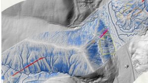
Woolpert Partners with Teren to Further Expand its Geospatial Services to Global Energy Customers
The combined industry-leading lidar capabilities and software solutions will help mitigate risk to critical pipeline and utility infrastructure. DENVER — Woolpert, a premier architecture, engineering, and geospatial (AEG) firm, announced today that it has…

Topcon 3D leveling system now compatible with new Dynapac Highway Paver series
MUNICH — Topcon Positioning Systems has announced that its MC-Max Asphalt paving system has been confirmed compatible with the Dynapac SD25 and XD25 Highway Paver series, enabling automatic control of height, steering, and screed width for enhanced paving…

Topcon launches CR-H1 handheld reality capture solution for maximum mobility
MUNICH — Topcon Positioning Systems has announced the CR-H1, a handheld solution that represents one of the latest additions to the company’s Capture Reality portfolio of mass data solutions. The system utilizes PIX4Dcatch, a specialized application that…

Topcon introduces solutions for 3D mass data workflows
MUNICH — Topcon Positioning Systems has announced new technology solutions for 3D mass data workflows. Enhancements to the Topcon Collage Site software solution provide new workflow capabilities designed to allow for the real-time acquisition and processing…
