

Green building design, energy efficiency, power usage efficiency, sustainability etc, are the buzzwords that are making waves across the architectural design industry. This is a two-way tunnel, where architecture is guiding social impact, and this very social…

SimpsonHaugh And Partners Use Generative Design to Shape One Blackfriars Tower Concept
London’s leading property developer, St. George PLC, retained SimpsonHaugh Architects to fulfill a vision for mixed-use development at the junction…

Building Studio Delivers Complex Large-Scale Projects
When Gerard Outram, CEO of Building Studio, founded his business in 2007, he did so with an eye to the future. “As a start-up business owner, I knew…
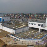
The Beauty Beneath: Notable Water and Sewer Networks Recognized
The Be Inspired Awards, awarded annually at Bentley Systems’ Year in Infrastructure Conference, are something like the Academy Awards of the infrastructure world—they recognize and celebrate design and construction achievements that often go unrecognized…

Transforming What Was Wet and Wasted in Wayzata
Declining Mall Redeveloped to Native Wetland Conditions By James W. Tiggelaar, PE, CCS, LEED AP The city of Wayzata, Minn., on the north shore of Lake Minnetonka, is a thriving community just 12 miles west of downtown Minneapolis. The lake has been…

BIM Scores at San Jose Earthquakes’ New Stadium
Designed to provide the best possible experience for Major League Soccer fans, Avaya Stadium is among the world’s most technically and structurally advanced stadiums. By Edgar Enchano When flying into the San Jose International Airport, you can’t help…
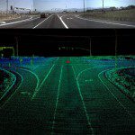
Consider the Benefits of Mobile LiDAR for Transportation Projects
Mobile LiDAR has become an effective solution for rapid data collection in recent years. For example, using mobile LiDAR imaging, the Utah Department of Transportation recently undertook a groundbreaking inventory of numerous roadway assets. Laser scanning…
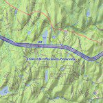
Mobile LiDAR Proves Cost Effective for Pavement Mapping
The Pennsylvania Department of Transportation (PennDOT) has used low-altitude mapping photography (LAMP), typically flown at 300 feet above mean terrain (AMT) via a helicopter, as a base for photogrammetry projects requiring high-accuracy pavement mapping…

Executive Corner: A/E Industry Consolidation, Let the Good Times Roll
It seems like almost every day, another merger or acquisition is announced between two architecture, engineering (A/E) or environmental-consulting firms. And although the global mega combinations such as URS-AECOM and Parsons Brinckerhoff-WSP draw the most…

Infrastructure Outlook: The Age of the Engineer
Several years ago, I was talking to a friend who said, “Bill, if mankind is going to be around in 250 years, it will be because engineers make it so.” It was an intriguing concept. Certainly, our planet is being asked to support an ever-growing human population…
