
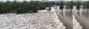
Simpson Strong-Tie has donated $30,000 to the Kerr County Flood Relief Fund following the destructive floods in Texas on July 4, 2025. Kerr County was one of the hardest-hit areas around the Guadalupe River, where the unprecedented flash flooding has…

Exodigo Brings AI Efficiency to Infrastructure Industry, Closes $96 Million Series B
Underground Mapping Innovator Doubles Valuation Based on Global Demand From Utility, Transportation and Infrastructure Leaders as Early Investors Double…

Drone Harmony and Pix4D announce strategic partnership to enhance drone mission planning workflows
Lausanne, July 15th, 2025 Drone Harmony, a leading provider of advanced drone mission planning software, and Pix4D, a global leader in photogrammetry…

Eagleview and SkyWatch Announce Alliance to Expand Access to Ultra High-Resolution Aerial Imagery
New collaboration brings Eagleview’s industry-leading imagery to the SkyWatch platform, including Esri’s Content Store for ArcGIS, for single image purchases. San Diego, CA and Rochester, NY – July 15, 2025 – Eagleview, a leading provider…

Partnership with Esri gives ArcGIS community easy access to species occurrence records
Software integration aims to increase use and citation of open data on biodiversity among geospatial platform users GBIF and geographic information system (GIS) technology leader Esri have launched a new partnership to facilitate the direct…

Esri Collaborates with Microsoft to Bring ArcGIS Users New AI Enhancements
Collaboration Will Integrate Microsoft Azure AI Foundry, Further Democratizing Geospatial Understanding and Workflows REDLANDS, Calif.— Esri, the global leader in geographic information system (GIS) technology, is integrating Microsoft Azure OpenAI Service…
Esri’s ArcGIS Basemaps Power Dataminr First Alert for Enhanced Real-Time Event Detection and Awareness
New Integration Enables Government Organizations to Better Manage Large-Scale Events, Emergency Response, and More REDLANDS, Calif. — Esri, the global leader in location intelligence, has partnered with Dataminr, the leading real-time AI…

Fugro and Esri collaborate to advance climate resilience
Image credit: EOMAP - a Fugro company Fugro has entered into a strategic collaboration with Esri, the global leader in geographic information system (GIS) software, to provide integrated geospatial solutions that empower climate resilience decision-making…

Meridiam and Aberdeen, Together as Golden Link Concessionaire, Celebrate 10 Years of The Presidio Parkway with Caltrans and San Francisco County Transportation Authority
he anniversary commemorates the delivery, opening, and first decade of successful operation of the Presidio Parkway SAN FRANCISCO – Today, Meridiam and Aberdeen, together as Golden Link Concessionaire (GLC), proudly celebrate the 10th anniversary of…

Stantec selected to support California Water Plan
California Water Plan Update 2028 will serve as the state’s strategic roadmap in a changing climate SACRAMENTO, CA: TSX, NYSE: STN: Stantec, a global leader in sustainable design and engineering, has been selected by the California Department…
