

PITTSBURGH, PA - RoadBotics is introducing a much-anticipated feature on its automated and objective road assessment platform, RoadWay, called HD-PCI, along with other enhancements to make pavement planning easier for its clients and partners. The official…

Esri Announces Launch of ArcGIS Field Maps
REDLANDS, Calif.- Esri, the global leader in location intelligence, today announced the launch of the ArcGIS Field Maps mobile app. ArcGIS Field Maps…

SimActive Releases Version 8.6 of Correlator3D™
Montreal, Canada – SimActive Inc., a world-leading developer of photogrammetry software, announces the release of Correlator3D™ version 8.6. The new…

Pix4D launches new ground image capture app for 3D modeling with the iPad Pro and iPhone 12 Pro
Lausanne, Switzerland, [November 10, 2020]: Pix4D, the photogrammetry industry leader, announces today the release of a new app product for ground images acquisition: Pix4Dcatch. Pix4Dcatch empowers users to easily create ground-based 3D models using an iOS…
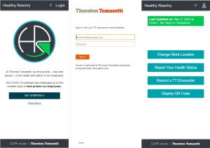
Thornton Tomasetti releases ‘Healthy Reentry’ free software to aid safe office return
Open Source App Provides Customizable Health Reporting And Contract Tracing Capabilities New York, NY – Thornton Tomasetti has open sourced its proprietary Healthy Reentry (HR) application for health monitoring and contract tracing. Designed…

Enscape Releases Version 2.9 With Vectorworks 2021 Integration
Milestone release adds Vectorworks to Enscape’s list of fully supported 3D modeling programs Columbia, MD (November 5, 2020)—Enscape GmbH, the leading provider of real-time rendering and virtual reality technology for the global architecture, engineering…

Leica Geosystems innovates automated total station portfolio
Range of automated total stations now with new integrated functionalities increase productivity in any environment (HEERBRUGG, Switzerland ) – Leica Geosystems, part of Hexagon, has enhanced the entire automated total stations portfolio in 2020. Starting…

Polygon Announces PolySlide® Composite Tubing for Pneumatic and Hydraulic Cylinders
Ideal for replacing metallic material in a variety of cylinder applications Walkerton, IN – Polygon Composites Technology, a leading manufacturer of composite tubing solutions for bearings, dielectric applications, surgical devices…
Virtual Surveyor Introduces Curb & Gutter Mapping in New Version of Drone Surveying Software
AARSCHOT, Belgium – Virtual Surveyor has introduced Curb & Gutter mapping functionality in Version 7.6 of its popular drone surveying software. The new capability enables surveyors to create a lightweight CAD model of curbs and gutters along the edges…

IntelliCAD Technology Consortium Announces Release of IntelliCAD® 10.0a
Portland, OR, USA — The IntelliCAD Technology Consortium (ITC) today announced the release of IntelliCAD 10.0a. IntelliCAD 10.0a is a maintenance release for version 10.0 that was previously issued on July 30, 2020. IntelliCAD maintenance releases concentrate…
