

Huntsville, AL – Baron, the worldwide provider of critical weather intelligence, has released a new product offering specifically designed for Department of Transportation services across the U.S. The solution will provide a single comprehensive source for…

Wilo USA Extends Range of Powerful Wilo-Stratos GIGA Line
Rosemont, IL. Wilo USA, a provider of pumps and pump solutions for water management, building services and groundwater, is pleased to announce an extended…
Trimble’s New Tunnel Solutions Streamline Workflows for Survey and Engineering Professionals
SUNNYVALE, Calif. — Trimble (NASDAQ:TRMB) announced today a suite of solutions that enhances productivity and efficiency for surveyors and professionals…

Leica Geosystems and Frank Lloyd Wright Foundation Team Up to Transform Taliesin West into an Immersive Online 3D Experience
HEERBRUGG, Switzerland & SCOTTSDALE, Ariz.- Leica Geosystems, part of Hexagon, industry leader in measurement technology, today announced a partnership with the Frank Lloyd Wright Foundation to capture, document, and deliver immersive 3D experiences featuring…
Trimble Catalyst Now Supports GLONASS, Delivering Faster, More Accurate and Reliable Positioning Performance
SUNNYVALE, Calif. —Trimble (NASDAQ: TRMB) announced today that its Trimble® Catalyst™ software-defined Global Navigation Satellite System (GNSS) receiver for Android phones and tablets has been updated to support GLONASS. The update demonstrates the advantages…

Streamlining Automated Inspection Technology for Transportation
Avitas Systems, a GE Venture, provides state-of-the-art, robotic based autonomous and semi-autonomous inspection management, smart scheduling, and safety compliance. The Avitas Systems cloud based platform uploads inspection data from a wide variety of sensors,…

Michael Baker International Revolutionizes Next-Generation 9-1-1 Transition with New DATAMARK® VEP GIS Solution and Services
Michael Baker International, a global leader in engineering, planning and consulting services, today announced that its geographic information system (GIS) business launched DATAMARK® VEP (Validate-Edit-Provision), a new software-as-a-service (SaaS)…

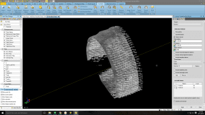
Hexagon Introduces World’s First 3D Laser Scanner with Automatic In-Field Pre-Registration
Hexagon AB, a global leader in digital solutions, today announced the launch of the Leica RTC360, a laser scanner equipped with edge computing technology to enable fast and highly accurate creation of 3D models in the field. It’s one of the many innovations…
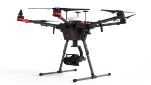
Leica Geosystems Combines New UAV Technology with DJI Aerial Platform to Complete Flight Missions in Less Time
(Heerbrugg, Switzerland) – Leica Geosystems, part of Hexagon, industry leader in measurement technology, announced today the new Leica Aibot, the latest Unmanned Aerial Vehicle (UAV) system based on DJI’s aerial platform, the M600 Pro, to rapidly…

New Leica iCON Construction Total Stations Provide Efficient Layout Solution
(Heerbrugg, Switzerland) – Leica Geosystems, part of Hexagon, industry leader of measurement technology, announced today the new Leica iCON construction total stations, Leica iCR70 and Leica iCR80, the most productive one-person layout solution…
