

Make your Autodesk Revit model immersive in one click with the Autodesk Revit Live service. From Revit, send your model to the Revit Live cloud and in just a few minutes, you will have a file that is ready to be opened, explored, and edited in the Autodesk…

Kaman Measuring Announces KD-2306 Non-Contact Displacement Sensing System
Middletown, CT – The Measuring Division of Kaman Precision Products, Inc., a world leader in the design and manufacture of high-performance, precision…

AutoCAD Plant 3D 2018 –Simplified Design from Design Creation, 3D Modeling to Collaboration
This past year has been exciting for the AutoCAD Plant 3D development team. We have added features that further simplify the design process by helping…
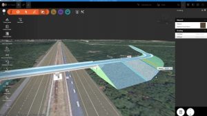
InfraWorks and AutoCAD Civil 3D 2018: They’re Here!
April 13, 2018. The latest Autodesk InfraWorks and Autodesk AutoCAD Civil 3D 2018 are officially released today. Throughout the year many of you have met with our product managers and development teams; and, many, many more of you have shared your Ideas…

Procore Users Can Print Plans Faster and Smarter for Much Less
Having printed sets of plans readily available for review is a necessity at building sites and in many other architecture, engineering and construction situations. Often, having plans on paper makes it easier for the project management team to see at a glance…

DroneDeploy Integrates with agX to Streamline Planning of Drone Mapping Flights
Stillwater, Okla.- STILLWATER, OK – DroneDeploy, the leading cloud software platform for commercial drones today announced an integration with agX® to help growers more easily capture field maps and analyze aerial data. agX users can now share field boundaries…
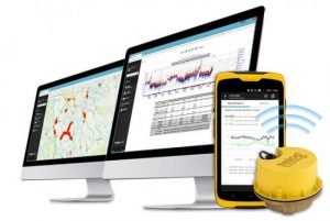
Trimble Unity Smart Water Management Software Adds Wireless Monitoring to Streamline Utility Operations
SUNNYVALE, Calif. — Trimble (NASDAQ: TRMB) announced today the latest version of its smart water management software—Trimble® Unity 3.8. Trimble Unity is a cloud-based, GIS-centric Software-as-a-Service (SaaS) solution that offers a suite of applications…
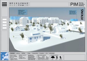
New Atkins Digital Tool Will Enable Collaborative Sustainable Urban Development Planning
A new digital tool to help stakeholders collaborate on sustainable urban growth is being developed by an Atkins team in Stockholm, Sweden. The project is funded by the Swedish Environmental Protection Agency as a part of a four-year €7 million government…

6 Major Construction Companies Adopt New Pix4D BIM Monitoring Solution
Construction professionals understand that daily visualization of a jobsite helps minimize construction delays, prevent clashes between as-built and as-design, eliminate the need for rework, facilitate stakeholder communication and align schedules. But how…

Going Digital: Bentley Systems Advances Reality Modeling to Extend the Scope of Engineering and Surveying Value
A 3D engineering-ready reality mesh created in ContextCapture comparing (left to right) photogrammetry, LiDAR, and a hybrid input. (Image courtesy of Bentley Systems and City of Strasbourg) Houston, TX – SPAR 3D Expo & Conference – Bentley Systems,…
