

World Water Works Arxtera, a leader in modern water treatment, announces the launch of its online shop of sustainable water treatment products and services. By supporting quick fulfillment and ease of accessibility, the new shop makes it easier for the company…

Polyglass Announces PolyanchorT SU – A Nailable Synthetic Roof Underlayment
Polyglass U.S.A., Inc., a leading manufacturer of building envelope and waterproofing solutions, is delighted to announce the release of PolyanchorÒ…
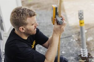
Ground Screws Pioneering Sustainable Foundations in Modern Construction
As the world increasingly gravitates towards sustainable development, the construction industry is at a crucial juncture. The call for environmentally…
Symetri Launches Naviate Zero, Advancing Sustainable Building Design with Innovative Green Technology
Addresses the urgent need for enhanced sustainable practices, reduced embodied carbon and CO2 emissions in the AECO and manufacturing industries Nashua, NH – Symetri, part of Addnode Group, and a leading global provider of design and engineering…

Bridge protection and traffic safety at its finest
The Great Belt Bridge in Denmark, one of the world’s longest suspension bridges, benefits from Structural Health Monitoring thanks to measurement technology by Kistler Kistler presents unique Structural Health Monitoring and Weigh In Motion portfolio…

Trimble Introduces Roadworks Paving Control Platform for Mills and Cold Planers
New version of Trimble’s next-generation paving control platform for smoother, more precise paving surfaces extends the functionality to an additional machine type WESTMINSTER, Colo., February 20, 2024 — Trimble (NASDAQ: TRMB) announced today the…
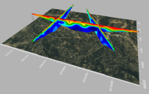
Latest Surfer® Mapping and 3D Visualization Package from Golden Software Gives Users Comprehensive View of Subsurface Data
Import imagery, such as PNG files of geophysical profiles, and position the images in any orientation! Import any georeferenced images, such as an aerial image in GeoTIFF format, and it is placed directly in the correct location. GOLDEN, Colorado, 13…

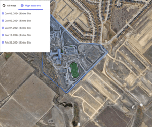
Esri Releases New Landsat Satellite Data App to View and Analyze Land Changes
andsat Explorer Makes Longest-Running Continuous Satellite Imagery More Accessible for Decision-Makers REDLANDS, Calif.—February 13, 2024—Esri, the global leader in mapping and location intelligence, announces the launch of Landsat Explorer, a groundbreaking…
Trimble and DroneDeploy Introduce Premier Positioning Accuracy and Streamlined Workflow for Reality Capture from Drones
RTX-based cloud positioning service expands project opportunities for drone mapping DENVER – GEO WEEK (Booth# 1001) – Trimble (NASDAQ: TRMB) announced today the integration of the Trimble Applanix POSPac CloudⓇ post-processed kinematic (PPK)…

DJI Launches Its First Intelligent 3D Model Editing Software DJI Modify
Makes repairing common 3D model defects simple and efficient January 18, 2024 – DJI, the world’s leader in civil drones and creative camera technology, today introduced DJI Modify, the company’s first intelligent 3D model editing software.…
