

HeavyRF solution offers a comprehensive view of how network assets serve customer experience at any scale; Charter Communications to collaborate for first deployment. SAN FRANCISCO– HEAVY.AI, an innovator in advanced analytics, today announced HeavyRF,…
Milwaukee-based TechRender LLC Announces High Tech Solution for Historic Preservation Industry
TechRender offers packaged solutions using advanced LIDAR scanning, drone photogrammetry and computer modeling services to revolutionize the historic…
InEight’s focus on standardization and benchmarking in software Innovations Update drive increased efficiencies and improved project confidence
Latest developments to InEight’s construction project management platform introduce new design management and benchmarking practices, improving consistency…

New Trimble TerraFlex Software Edition Simplifies GIS Data Capture
SUNNYVALE, Calif.— Trimble (NASDAQ: TRMB) announced today the release of Trimble® TerraFlex Premium edition, a new tier of Trimble’s flagship Geographic Information System (GIS) data collection software. The edition provides customers with offline GNSS…
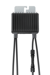
SolarEdge Launches Next-Gen C&I Smart Power Optimizer Series with a Multi-Layered Safety Technology at RE+ North America
SolarEdge Sense Connect is an industry-first technology that detects temperature increase at the connector level to prevent potential electric arcs New S-Series Power Optimizers include new sensor technology for improved safety in Commercial PV MILPITAS,…
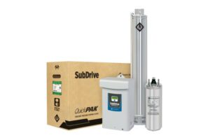
Franklin Electric SubDrive QuickPAKs Now Pair Groundbreaking Efficiency with Proven Reliability
Fort Wayne, IN – Franklin Electric Co., Inc. (NASDAQ: FELE) announced new SubDrive QuickPAK solutions for water system installers looking to deliver reliable constant water pressure while maximizing efficiency. The newest SubDrive QuickPAKs are powered…
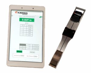
Kaman Announces New Air Gap Tool
Simple, Accurate Measuring and Data Storage for Hydroelectric Turbines Middletown, CT – The Measuring Division of Kaman Precision Products, Inc., the world leader in the design and manufacture of high-performance position measurement systems, announces its…

Getech’s Globe 2022 Release Deepens Geoenergy Resource Insights
Understanding how the Earth was formed is key to the efficient discovery and economic development of both traditional and transition energy resources. These will be fundamental to societies meeting their energy needs and net zero targets. Globe 2022 is…
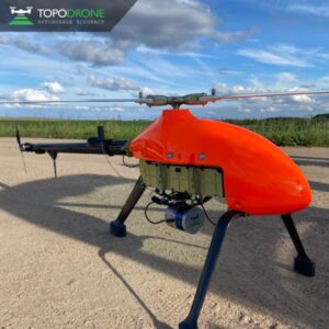
Elevating high-precision aerial lidar mapping with TOPODRONE and Velodyne Lidar
September 14, 2022 - Montreux, Switzerland - TOPODRONE, a Swiss based designer and manufacturer of high-precision lidar equipment for installation on drones, vehicles and backpacks, has announced the synchronization of LiDAR PRIME scanner and aOrion Heli-E…
Golden Software Enhances Grid Displays and Data Coordinate Conversion in Latest Surfer® Surface Mapping Package
Disperse Labels command makes the map easier to read by moving object labels so they don’t overlap. GOLDEN, Colorado – Golden Software, a developer of affordable 2D and 3D scientific modeling packages, has upgraded its Surfer® gridding, contouring,…
