

Milestone release adds Vectorworks to Enscape’s list of fully supported 3D modeling programs Columbia, MD (November 5, 2020)—Enscape GmbH, the leading provider of real-time rendering and virtual reality technology for the global architecture, engineering…

Leica Geosystems innovates automated total station portfolio
Range of automated total stations now with new integrated functionalities increase productivity in any environment (HEERBRUGG, Switzerland ) –…
Virtual Surveyor Introduces Curb & Gutter Mapping in New Version of Drone Surveying Software
AARSCHOT, Belgium – Virtual Surveyor has introduced Curb & Gutter mapping functionality in Version 7.6 of its popular drone surveying software.…
Connected Vehicle Sensors Installed in East Hawaii
HILO – The Hawaii Department of Transportation (HDOT) is pleased to announce the installation of Blyncsy Intersect Connected Vehicle units on the 16 state-owned traffic signals in East Hawaii in cooperation with Elemental Excelerator. These connected vehicle…

IntelliCAD Technology Consortium Announces Release of IntelliCAD® 10.0a
Portland, OR, USA — The IntelliCAD Technology Consortium (ITC) today announced the release of IntelliCAD 10.0a. IntelliCAD 10.0a is a maintenance release for version 10.0 that was previously issued on July 30, 2020. IntelliCAD maintenance releases concentrate…

UP42 Partners with Intermap to Bring High-Resolution Elevation Data to UP42’s Geospatial Marketplace
NEXTMap Digital Surface Model (DSM) BERLIN, Germany – UP42 is pleased to announce that the NEXTMap Elevation Data Suite from Intermap Technologies is now offered on the UP42 developer platform for Earth observation data and analytics. The NEXTMap…
OnScale Introduces OnScale Solve™: The World’s First Cloud Engineering Simulation Platform
Silicon Valley, CA – OnScale today announced the release of the OnScale Solve, the web-based cloud engineering simulation platform bringing to engineers powerful multiphysics solvers and scalable cloud supercomputer resources. “OnScale Solve gives…

New Swedish technology to support a greener aviation recovery
Flying is like competition sailing: it is all about using good winds and avoiding unfavorable air currents. To allow airlines to fully use the favorable winds there is a new weather optimization service available that shows exactly how the wind blows and where…

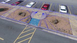
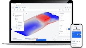
Datumate Announces Autodesk BIM 360 Integration for Improved Construction Site Visualization and Project Management
No-code integration empowers planning and construction teams with essential construction intelligence extracted in near real-time from survey-grade reality captures. YOKNEAM, Israel – Datumate, developer of the DatuBIM Construction Data Analytics platform,…

GSSI Updates to StructureScan™ Mini XT GPR Kit and Palm XT Antenna
GSSI, the world’s leading manufacturer of ground penetrating radar (GPR) equipment, announces new updates to the StructureScan™ Mini XT all-in-one GPR concrete inspection system, including a software update and a newly designed survey wheel for the Palm…
