
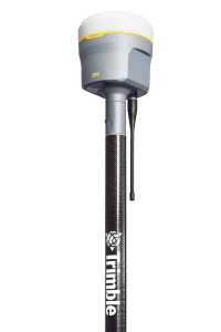
Trimble R12i GNSS Receiver Incorporates Robust Tilt Compensation to Increase Productivity for Land Surveyors SUNNYVALE, Calif.—Trimble (NASDAQ: TRMB) introduced today the Trimble® R12i GNSS receiver, the latest addition to its Global Navigation Satellite…

Bentley Institute Press Announces Availability of Infrastructure Digital Twins: A Leadership Short Course – Volume 1: Getting to Know iTwins
EXTON, Pa. – Bentley Institute Press, publisher of cutting-edge textbooks and professional reference works for the advancement of the engineering, architectural,…
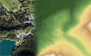
Elevate your performance with UltraMap 5.0
Graz, Austria: Vexcel Imaging announces the release of UltraMap version 5.0, the latest update of its all-in-one aerial…

Eos Positioning Systems announces compatibility of Eos Laser Mapping™ and Eos Locate™ with Esri ArcGIS Field Maps (beta)
The August 2020 release of Eos Tools Pro version 1.89 makes Eos Locate™ for ArcGIS (underground mapping) and Eos Laser Mapping immediately available for use with the Field Maps beta AUGUST 2020, MONTREAL, CANADA — Eos Positioning Systems (Eos), the Canadian…

The PV software archelios™ Pro Silver: manage projects up to 100 kWp
Trace Software International is excited to announce the launch of the newest editions of archelios™ Pro. The software is an excellent tool for the feasibility and bankability study, simulation, 3D design, and sizing of any photovoltaic project. As the solar…

PennDOT Earns Regional America’s Transportation Awards for Operations Excellence and Best Use of Technology
Harrisburg, PA – The Pennsylvania Department of Transportation (PennDOT) recently received regional America's Transportation Awards for operational excellence and best use of technology. The department's operational excellence award was for the Automated…
Xylem’s revolutionary Leopold Type 360 underdrain features innovative backwashing capability
New bolt down model increases efficiency RYE BROOK, N.Y., – Xylem now offers the Leopold Type 360 underdrain, a bolt down underdrain system for greenfield projects and water treatment filtration rehabilitation projects. The underdrain system has an…
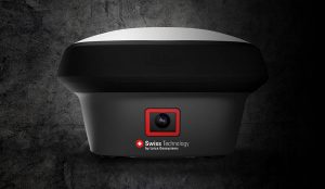
GNSS RTK rover with Visual Positioning increases safety, simplifies surveying
New GS18 I GNSS RTK rover with Visual Positioning can measure what you see (HEERBRUGG, SWITZERLAND, 18, August 2020) – Leica Geosystems, part of Hexagon, unveils the Leica GS18 I (announced by Hexagon yesterday), a versatile, GNSS RTK rover with Visual…
Milwaukee Tool Integrates One-Key™ with Autodesk BIM 360®
MILWAUKEE, WI - Milwaukee Tool is proud to announce that their One-Key™ digital platform now integrates with Autodesk Construction Cloud™’s BIM 360® construction management software, enabling customers to seamlessly share information between the two…
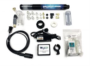
Q.E.D. MicroPurge MP25 Simplifies Low-Flow Groundwater Sampling
Purge stabilization flow cell ensures accuracy and consistency Dexter, MI – Q.E.D. Environmental Systems, Inc., a leading manufacturer of innovative environmental products and subsidiary of Graco Inc., highlights that its MicroPurgeÒ MP25 Purge Stabilization…
