
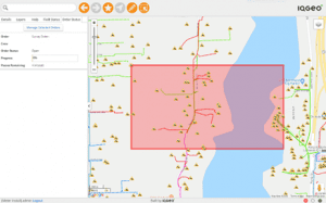
Cambridge – IQGeo (AIM: IQG), developer of mobile-first geospatial productivity and collaboration solutions for the telecoms and utility industries, is helping Peninsula Light to create a digital twin of its electric network and a new mobile meter…

Polyglass Enhances ADESO Self-Adhered Membranes
Advanced self-adhered roofing membranes reduce installation time and labor cost DEERFIELD BEACH, FL— Polyglass U.S.A., Inc., a leading manufacturer…
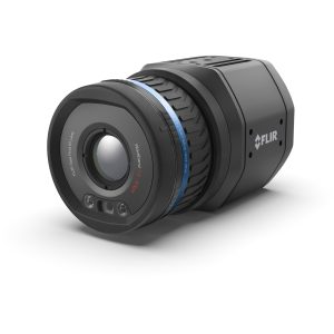
FLIR Launches its First Uncooled, Fixed-Mount, Connected Thermal Camera for Detecting Methane: GF77a
FLIR GF77a Offers Low-Cost Optical Gas Imaging Solution for Continuous and Autonomous Leak Detection ARLINGTON, Va.– FLIR Systems, Inc. (NASDAQ: FLIR)…
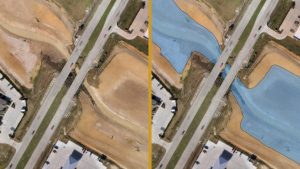
Virtual Surveyor Streamlines Volumetric Calculations for Stormwater Retention Ponds, Basins & Quarries
AARSCHOT, Belgium – Virtual Surveyor has released Version 7.1 of its popular drone surveying software, introducing functionality to efficiently calculate volumetrics in quarries, mine pits, retention ponds, and other basins that fill with water. This new…

GeoBase Team Wins AFIMSC Team of the Year Award
The AFCEC GIO team is comprised of more than 50 geospatial professionals, most of whom work at Woolpert. JOINT BASE SAN ANTONIO-LACKLAND, Texas — The Air Force Civil Engineer Center (AFCEC) Geospatial Integration Office (GIO) GeoBase team was honored…

KOREC and NCTech launch KlearView360°
Companies join forces on vehicle-based visual asset inspection and verification system Liverpool & Edinburgh, UK – KOREC and NCTech today announced the launch of KlearView360°, a streamlined, hosted system designed for the identification of assets,…

Enscape Introduces Version 2.7 of its Real-Time Rendering Software
New BIM-driven Workflows and Enhanced Performance Make Enscape the Perfect Complement to the Building Design Process Karlsruhe, Germany — Enscape, the leading provider of real-time rendering and visualization technology to the global Architectural, Engineering,…

HDR Selected to Bring PennDOT’s Vision of 3D-Only Plans to Reality
OMAHA, Neb. — The Pennsylvania Department of Transportation has selected HDR to assist it in developing and implementing its 3D Digital Delivery initiative. The game-changing effort will redefine how infrastructure projects are designed and delivered in…

Leica Geosystems announces new most accurate total station
Leica Nova TS60 minimises costs and downtime with sub-second and sub-millimetre accuracy, newly integrated DynamicLock and AutoHeight features. Heerbrugg, Switzerland – Leica Geosystems, part of Hexagon, announced today the new Leica Nova TS60, the…

Leica Geosystems Brings the World’s First MultiStation to the Next Level
The new version of Leica Nova MS60 enables users to perform all surveying tasks with one instrument (Heerbrugg, Switzerland, 18 February 2020) – Leica Geosystems, part of Hexagon, announced today the new Leica Nova MS60. The MS60 MultiStation, brings…
