

San Francisco, CA – Ideate Software, a veteran Autodesk Developer Network member, announced enhancements to Ideate BIMLink, its Revit productivity application that simplifies model management by facilitating the movement of data from Autodesk® Revit® software…
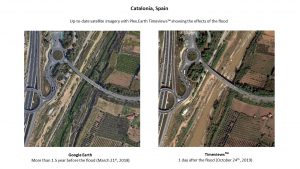
Plex.Earth Timeviews™ empowers AEC professionals with the latest satellite imagery within AutoCAD
Plexscape, developers of Plex.Earth®, one of the most popular tools for AutoCAD for the acceleration of architectural, engineering and construction (AEC)…
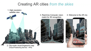
Sturfee Rolls out World’s First AR Cloud Technology for Cities that Uses Satellite Imagery to Create Magical City Experiences
Sturfee’s disruptive approach makes your smartphone cameras recognize streets using AI and Satellgery; major Japanese telco KDDI is already incorporating…
Trimble Clarity Now Offered as Web Application for Point Clouds and 3D Models
SUNNYVALE, Calif.— Trimble (NASDAQ: TRMB) announced today that Trimble® Clarity is available as a stand-alone web application that simplifies the visualization and navigation of 3D data. With this major update, Trimble Clarity enables geospatial professionals…
Trimble Announces Availability of the XR10 with HoloLens 2, a Next-Generation Mixed-Reality Solution for Front-Line Workers in Safety-Controlled Environments
DÜSSELDORF, Germany, Nov. 8, 2019—Trimble (NASDAQ: TRMB) announced today that it is now taking orders for the Trimble® XR10 with HoloLens 2 system, a worksite-ready mixed-reality solution that enables workers to visualize 3D data on project sites for easier…

Vectorworks, Inc. Brings Ultimate GIS Workflow to AEC and Landscape Professionals
Columbia, MD — GIS helps designers make better decisions. This is why Vectorworks, Inc., a global design and BIM software provider and its partner Esri, the global leader in location intelligence, are bringing Esri’s ArcGIS Online services to AEC and landscape…

Cesium Takes City Visualizations Into the 3rd Dimension Through Open-Source Collaboration
Philadelphia – A new open-source initiative by Cesium™, the market leader in streaming 3D geospatial technology will address the need to visualize, analyze, and share the world’s vast and ever-growing collection of 3D geospatial data. Engineering…
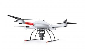
Microdrones is Taking Photogrammetry to New Heights with the mdMapper3000DuoG VHR
Rome, NY - Rome, NY – Microdrones is releasing three new Integrated UAV Systems based on the heavy lifting power, resilience and efficiency of the Microdrones md4-3000 aircraft: the mdMapper3000DuoG VHR, the mdMapper3000DuoG, and the mdMapper3000 PPK. …

ARTBA Transportation Investment Advocacy Center Rolls Out New Website
www.transportationinvestment.org designed to help boost state and local campaigns WASHINGTON - A new website from the Transportation Investment Advocacy Center™ (TIAC) provides easy access to a variety information sources on state and local transportation…
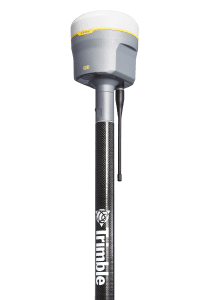
New Trimble R12 Receiver Boosts Surveying Performance
SUNNYVALE, Calif. - Trimble (NASDAQ: TRMB) introduced today the Trimble® R12 GNSS receiver, a high-performance Global Navigation Satellite System (GNSS) surveying solution. Powered by an all new Real Time Kinematic (RTK) and Trimble RTX® positioning…
