
Autodesk first introduced the integration of BIM and Esri’s GIS data through InfraWorks, enabling the opportunity of better infrastructure design by establishing a richer, real-world context model of the project. InfraWorks design software supports BIM processes.…
Pype Secures Second Patent and Multiple ENR Enterprise Partnerships Following Rapid Growth
WASHINGTON - Pype, a leading software-as-a-service (SaaS) provider for the construction industry has experienced tremendous growth this year following…

HxGN Content Program Now Offers High-definition Aerial Data in the United States
HxGN Content Program now offers high-definition aerial data in the United States WASHINTON, D.C., USA (24 September 2019) — Hexagon’s…
Ground Penetrating Radar: The Unlikely New Hero of Autonomous Vehicles
GSSI, the world’s leading manufacturer of ground penetrating radar (GPR) equipment, announces TerraVision™, the first-to-market localizing ground penetrating radar (LGPR) technology that improves navigation for autonomous vehicles (AVs). The LGPR technology…
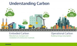
Skanska USA Conceives Solution for Calculating Embodied Carbon in Construction Materials, Announces Transition to Open-Source Tool
New York - Skanska USA, alongside the Carbon Leadership Forum and partners in industry, today announced the creation of the Embodied Carbon in Construction Calculator (“EC3”) tool, a ground-breaking solution for calculating and evaluating the carbon emissions…
Trimble Announces New Release of Advanced Wastewater Monitoring and Analytics Software for Municipalities and Utilities
CHICAGO - Trimble (NASDAQ: TRMB) introduced today the latest version of its Trimble Unity™ Remote Monitoring software for water, wastewater and stormwater utilities. Version 4.7 provides new analytics and visualization capabilities, enabling utilities…
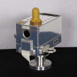
Jacobs Develops Wireless Portable HD Camera System for NASA
DALLAS - Jacobs (NYSE: JEC), in partnership with NASA, recently achieved a milestone on August 21, 2019, as NASA astronauts successfully deployed and used a wireless high-definition camera system for the first time during their extravehicular activity…

Topcon introduces new technology advancements in inspection and monitoring
STUTTGART, Germany – Topcon Positioning Group announces advancements in its inspection and monitoring portfolio designed to ensure longer term health of buildings and infrastructure assets. Among the improvements announced at INTERGEO 2019 include…

Woolpert Launches STREAM:RASTER to Host and Support Imagery in the Cloud
The subscription software service is geared toward organizations that manage GIS data and infrastructure. DENVER (Sept. 20, 2019) — Woolpert announced today that it is launching STREAM:RASTER, a subscription software service that hosts and facilitates access…

Epson Now Shipping Moverio Assist “See-What-I-See” Remote Assistance Solution
LONG BEACH, Calif. – Epson today announced Epson Moverio Assist is now available. The easy-to-use remote assistance and inspection solution using Moverio® smart glasses enables enterprises to address difficult repairs and work tasks out in the field in…
