

The latest iteration of Ideagen’s quality, safety, risk and compliance management software comes with powerful dashboards and an intuitive user experience Ideagen, the governance, risk and compliance (GRC) software provider, has launched a new and…
eGlobalTech Launches Artificial Intelligence Solution Auxilium
PASADENA, Calif. - Tetra Tech, Inc. (NASDAQ: TTEK) announced today that eGlobalTech, A Tetra Tech Company, launched Auxilium, eGlobalTech’s premier…
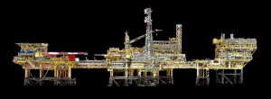
Terra Drone Europe Conducts Oil Rig Platform Survey and 3D Modeling for Shell
Using modern GNSS techniques, the location of each and every asset on the rig platform was determined to facilitate accurate drill rig positioning Terra…
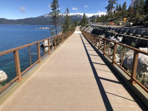
FRP Takes On Major Role In Nevada DOT State Route 28 Shared-Use Path Project
DAYTON, Ohio - Every year more than 1 million visitors travel Nevada State Route 28—a two-lane, mountainside road that borders 11 miles of Lake Tahoe’s undeveloped shoreline. With usage expected to double in the next 20 years, limited parking and lack…
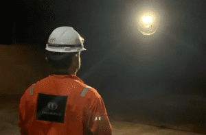
Terra Drone Brazil Complete Brazil’s First FPSO Tank Inspection Using Drones for Petrobras
Rio de Janeiro, Brazil – Terra Drone Brazil, a group company of Japan-based Terra Drone Corporation has announced the successful completion of Brazil’s first-ever drone inspection of an offshore FPSO tank. The ballast tank inspection using drones…

Ideate Software eLearning Assets now Available in Pinnacle Series by Eagle Point Software
San Francisco, CA – Ideate Software, a veteran Autodesk Developer Network member, announced that its Revit workflow and training content is now available to users of Eagle Point Software’s Pinnacle Series. Pinnacle Series is a platform designed to help…
Leica Geosystems Introduces New Generation of Manual Construction Total Stations
The new Leica iCON manual total stations digitalise measurement methods with simplified workflows (Heerbrugg, Switzerland, 18 July 2019) – Leica Geosystems, part of Hexagon, announced today the next generation of iCON manual total stations, the Leica iCON…
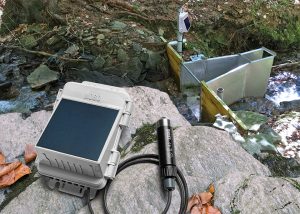
New HOBO® MicroRX Water Level Station from Onset Enables Simple, Cost-Effective Monitoring of Stormwater, Floodwater, Irrigation, and Other Water Systems
MicroRX Water Level Station provides immediate visibility into water level and flow data via 4G cellular technology and cloud-based software BOURNE, MA, July 18, 2019—Minutes can make the difference when it comes to mitigating the effects of floodwaters,…
Trimble 4D Control Software Delivers Streamlined Real-Time Monitoring System Deployment and Simplified Geotechnical Sensor Support
Increased Capabilities Save Days of Setup Time for Real-Time Structural Monitoring Projects SUNNYVALE, Calif., — Trimble (NASDAQ: TRMB) introduced today the latest version of its core real-time monitoring software—Trimble® 4D Control software.…
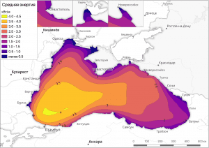
Geographers of the Lomonosov Moscow State University published the web-atlas of the available wave energy in the Russian seas
Wave energy distribution in the Black Sea(above) Scientists from Lomonosov MSU (Faculty of Geography) have published the first version of the Russian wave energy web-atlas. The test version of the web-atlas posted at http://autolab.geogr.msu.ru/wavenergy…
