
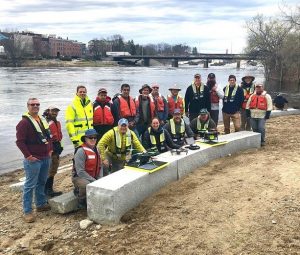
AUBURN, Maine — U.S. Geological Survey (USGS) and independent scientists gathered this month in Auburn, Maine, to evaluate the use of sensor-mounted unmanned aircraft systems (UAS), or drones, to gauge stream stage, velocity, bathymetry and discharge. The…
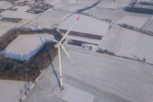
Storm gets on board with Greenbyte Energy Cloud for data management
The Belgian wind farm developer chose Greenbyte Energy Cloud for data management of their operational wind farms of 100 MW all over Belgium and Ireland.…

Topcon Announces Next Generation Flight Planning Software
LIVERMORE, Calif., U.S./ CAPELLE A/D IJSSEL, the Netherlands – Topcon Positioning Group announces the next generation flight planning system for…

Topcon Announces Advanced Bentley Integration for Aerial Photogrammetry Processing
LIVERMORE, Calif. & CAPELLE A/D IJSSEL, Netherlands - Topcon Positioning Group announces new cloud-based photogrammetry processing powered by Bentley ContextCapture to its MAGNET Collage Web web-based service for publication, sharing, and analysis of reality…
New Complete Ecosystem Created with Smallest Imaging Laser Scanner, Award-Winning Mobile-Device App
(HEERBRUGG, SWITZERLAND, 22 MAY 2019) - Leica Geosystems, part of Hexagon, today announced the Leica Cyclone FIELD 360 laser scanning mobile-device app now works in conjunction with the Leica BLK360 imaging laser scanner to create a laser scanning…

Trimble Releases Next-Generation Integrated Smartphone and GIS Data Collector
SUNNYVALE, Calif.— Trimble (NASDAQ: TRMB) introduced today the Trimble® TDC600 handheld, an ultra-rugged, all-in-one smartphone and Global Navigation Satellite System (GNSS) data collector for Geographic Information System (GIS) and field inspection…

Delair Introduces Open Payload Version of Long-Range UAV to Enable Custom Configuration of Sensing Capabilities
TOULOUSE, France – Delair, a leading supplier of commercial drone solutions, today introduced a new model of its popular long-range UAV, the Delair DT26, which offers an easy-to-integrate architecture for adding user-specified sensors and other…

Gaist’s Mapping Solution Could Boost Efficiency for Utilities Market by 10 Per Cent at 0.01% of Project Cost
London, UK – Utilities companies looking to cut the cost and time of their construction works today have a new solution available to them as Gaist revealed its unique infrastructure digital twin has the potential to increase efficiency output by 10 per cent…

IMAGINiT Clarity 2020 Improves Revit Project Management
BALTIMORE, MD — IMAGINiT Technologies’ latest release of the Clarity 2020 suite of products optimizes the BIM team’s efficiency by automating manual work, unlocking insights for easy analysis and seamless sharing of Autodesk Revit data across the…
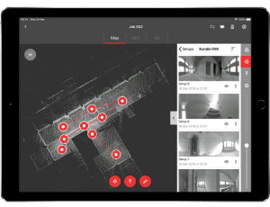
Topcon Introduces Real-Time Reality Capture Solution
LIVERMORE, Calif. – Topcon Positioning Group announces its new real-time reality capture solution for building construction verification will be demonstrated at the SPAR 3D Expo and Conference — the GTL-1000. The new real-time…
