

(Heerbrugg, Switzerland, 26 September 2017) – Leica Geosystems, industry leader of measurement technology, announced today the Leica GS18 T, the world’s fastest GNSS RTK rover, and the latest versions of Leica Captivate field software and Leica Infinity…

GeoSLAM Launching Enhanced SLAM Software and Next Generation Mobile Scanner at InterGEO 2017
NOTTINGHAMSHIRE, UK, 25 September 2017 – GeoSLAM, the experts in “Go-Anywhere” 3D mobile mapping, will launch the latest version of its award-winning…

SBG Systems to Launch the “SBG +Services”, a Full Set of Technical Services Around its Inertial Sensors
Carrières-sur-Seine, France – SBG Systems, leading manufacturer of inertial navigation systems, adds to its catalog a full set of technical services…

VDOT Unveils Website for I-66 Express Lanes Inside the Beltway
FAIRFAX - With express lanes opening this December on I-66 Inside the Beltway, the Virginia Department of Transportation (VDOT) unveiled a new website, 66ExpressLanes.org, to educate travelers about how tolling will work, the necessity of getting…

GeoCue Group Provides Free LIDAR Data for Hurricane Impact Areas
Huntsville, AL – GeoCue Group, in partnership with the United States Geological Survey and with support from the Texas Natural Resources Information System (TNRIS) is providing free access to pre-event LIDAR and imagery data in the areas impacted by hurricanes…

Bentley’s AECOsim Building Designer CONNECT Edition Surmounts the Challenges of BIM Scalability for Major Projects
EXTON, PA, U.S.A. – Bentley Systems, Incorporated, a leading global provider of comprehensive software solutions for advancing infrastructure, today announced the availability of AECOsim Building Designer CONNECT Edition, Bentley’s building information…

NCDOT Reminds Drone Hobbyists: No Drones in Disaster Zones
RALEIGH – As Hurricane Irma approaches, the N.C. Department of Transportation Division of Aviation’s Unmanned Aircraft Systems Team is urging drone hobbyists not to fly while disaster relief and response efforts are ongoing. While licensed and well-trained…

Skyfront Sets World Record for Drones with 4 Hour and 34 Minute Flight
MENLO PARK, CA, SEPT. 14, 2017 – Skyfront, creator of the world’s longest endurance multirotor drones for the agriculture, energy and utility industries, has announced that its flagship drone has just set a world record for endurance. The Skyfront…
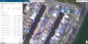
New Airbus Aerial Technology Impacts Hurricane Irma Recovery Efforts
ATLANTA - As residents and insurers in the southeastern United States begin to consider recovery efforts following Hurricane Irma, Airbus Aerial is prepared to help by providing insurance companies free initial access to its library of aerial base maps and…

Virtual Reality, Fabrication and Other Capabilities Come to Autodesk’s AEC Collection at No Additional Cost
Tools that extend Revit models for virtual reality, fabrication, computational design, and analysis support BIM processes from planning and design through preconstruction. By Vikram Dutt, Sr. Director, Building Business Line We have some exciting…
