

Esri's Marc Goldman, Kris Hirte and Clay Starr are joined by Todd Danielson, editorial director of Informed Infrastructure and V1 Media, and Brian Skripac with Design-Build Institute of America (DBIA) in a conversation on industry and GIS trends in the architecture,…

Space and Building Management Software Converge with Digital Twins to Ignite a 29% CAGR Surge in Global Net-Zero Energy Buildings by 2027
The count of net-zero energy buildings worldwide will experience significant expansion in the coming years, according to a new report from global technology…

Holcim Launches Phoenix, the First-Of-Its-Kind Circular 3D-Printed Concrete Bridge
Phoenix, 3D-printed concrete masonry bridge Block Research Group© First 3D-printed concrete bridge built with recycled materials in Holcim proprietary…
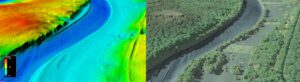
USGS publishes new topobathymetric data powered by Teledyne Geospatial CZMIL SuperNova lidar system
Vaughan, Ontario, CANADA – Teledyne Geospatial congratulates the U.S. Geological Survey (USGS) and Dewberry, a privately held professional services firm, on the publication of a new topobathymetric lidar dataset for the Potomac River. The Potomac River flows…

California Engineering Contractors (CEC) Adopts Industry-First Schedule Risk Analysis Tool from Planera to Manage Complex Projects
Leading West Coast contractor implements advanced tool to boost visibility, eliminate guesswork, and revolutionize how construction managers quantify and manage risk San Jose, CA – December 13, 2023 — Planera, a construction CPM scheduling and planning…

Tech Soft 3D Introduces HOOPS Luminate for Advanced Desktop Rendering
HOOPS Luminate provides developers with photo-realistic and advanced real-time rendering for engineering applications in digital construction, product development, and interior design New graphics toolkit provides developers with photo-realistic and…
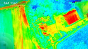
TOPODRONE-AGROWING collaboration aims at advancing drone thermal mapping
Thermal data captured with TOPODRONE PT61 camera © TOPODRONE Montreux, Switzerland – TOPODRONE, a Swiss based designer and manufacturer of high-precision surveying equipment, recently completed its R&D and released a new drone thermal mapping…

GlobalData Highlights Transformative Impact of AR/VR Technologies in Construction Industry
The construction industry is on the brink of a profound shift with the integration of augmented and virtual reality (AR/VR) technologies. These advancements promise a radical redefinition of design, planning, and execution in construction projects. The collaborative…

Yunex Launches Yutraffic Studio – Customer Inspired, Cloud-Based Advanced Traffic Management System in the US
Introduction of an advanced cloud-based Automated Traffic Management System (ATMS) designed based on customer feedback. Yutraffic Studio supports customer workflows and user experience, offering high-quality planning, monitoring, and optimization tools derived…
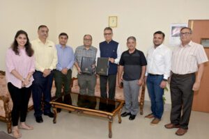
Trimble Contributes Inertial Navigation Solutions to the Indian Institute of Technology in Kanpur Supporting the Country’s Commitment to Becoming a Leader in the UAV Industry
Students in India to learn with the latest, cutting-edge UAV mapping technology WESTMINSTER, Colo., Nov. 29, 2023 – Trimble (NASDAQ: TRMB) announced today a collaboration with the Indian Institute of Technology in Kanpur (IIT Kanpur) to support a…
