
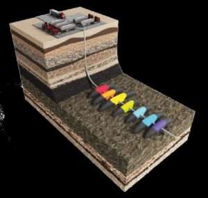
HOUSTON - CARBO and GEOSPLIT announced today that the companies have entered into a strategic partnership that will enable energy operators to improve their reservoir performance by optimizing drilling & completions designs through understanding the…
Chung-Ang University Researchers Use Deep Learning to Develop a Forecasting Model for Efficiently Managing Electric Grids
The model accurately predicts uncertain parameters related to renewable energy sources for microgrid operation, their energy demand, and market prices …

Immersal Oy launches Immersal City-Scale Visual Positioning System
The new 5G-enabled smart city Visual Positioning System offers unmatched accuracy and new business opportunities for mobile network operators and their…
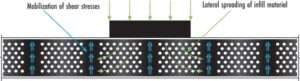
Article Sheds Light on the Power of Geocells in Load Support Applications
Geocells are one of the most valuable tools in the civil engineering and construction industries today. When constructing roadways over soft soils and weak subgrades, geocells can make a significant impact. However, some engineers may be uncertain about using…
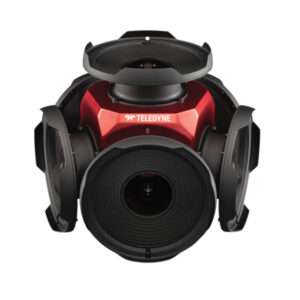
Teledyne’s New Ladybug6 Camera for High-Accuracy 360-Degree Spherical Image Capture Now Shipping
Richmond, CANADA - Teledyne FLIR is pleased to announce its all new Ladybug6 360-degree camera is now in full production. “We are excited to announce that our newest Ladybug camera is in production now and units are shipping immediately. The interest expressed…
DuPont Consolidates Ultrafiltration Technologies Under New IntegraTec™ Brand
To better serve municipal and industrial customers, DuPont is consolidating and rebranding its diverse portfolio of ultrafiltration (UF) membranes for the sustainable purification, conservation and reuse of water. The DuPont™ IntegraTec™ portfolio…
Leica Geosystems announces performance upgrades for airborne deep bathymetric surveys
The new Leica HawkEye-5 bathymetric LiDAR sensor provides a significant improvement in flight efficiency for detailed data capture in deep waters (Heerbrugg, Switzerland) — Leica Geosystems, part of Hexagon, announced today the release of the Leica…

Teledyne Geospatial revolutionizes airborne lidar ROI with Galaxy Onboard: a real-time workflow solution
Vaughan, Ontario, CANADA – Teledyne Geospatial announced the release of the Galaxy Onboard, a workflow-focused solution that enables airborne surveyors to deliver quality-controlled processed data in real time. With Galaxy Onboard, Teledyne Geospatial has…

StormTrap’s New Stormwater Treatment Device, StormSettler, Receives New Jersey Department of Environmental Protection Certification Under Latest Protocol
StormSettler, developed by StormTrap, is a highly efficient stormwater treatment settling device that improves the quality of stormwater runoff. ROMEOVILLE, Ill.- StormTrap® announced today the release of the new stormwater treatment device, StormSettler™.…

Golden Software Adds Powerful New 3D Subsurface Visualization Functionality to Surfer® Surface Mapping Package
Interpolate and visualize 3D data, such as subsurface soil or groundwater contamination, mineralization concentration, seismic refraction velocity, temperature distribution, or dissolved oxygen concentration. GOLDEN, Colorado – Golden Software’s…
