
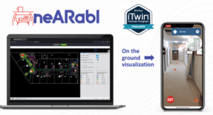
Nearabl Inc. achieves “Powered by iTwin” designation and becomes an iTwin Premier Partner, joining a growing digital twin ecosystem to scale infrastructure deployments globally New York, N.Y. –Today, Nearabl Inc., the metaverse of accessibility…
Leica Geosystems launches next-generation Leica iCON gps 160 — the most versatile construction Smart Antenna
(Heerbrugg, Switzerland) Leica Geosystems, part of Hexagon, today announced the launch of Leica iCON gps 160 — a significantly enhanced, next-generation…

Brokk to Showcase New Innovations at Bauma 2022
The Brokk Grapple Saw 15 is two attachments in one. It can cut metal pipes with a diameter of up to approximately 200 millimeters (7.87 inches) and grab…

Vexcel Imaging unveils its new UltraNav version 7 including a new partnership with TopoFlight
Graz, Austria: From the Intergeo 2022 in Essen, Germany, Vexcel Imaging introduces the next version of UltraNav, its all-in-one Flight Management and direct georeferencing solution. UltraNav version 7 guides customers every step of the way from 3D Flight…
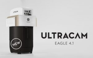
Vexcel introduces new UltraCam Eagle 4.1 photogrammetric aerial camera
Graz, Austria: Vexcel Imaging today announces the release of the new UltraCam Eagle 4.1, the pinnacle of nadir photogrammetric aerial camera systems increasing flight efficiency at truly mapping-grade image quality for precise analysis and interpretation.…
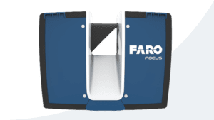
FARO Releases Focus Core Laser Scanner
Lake Mary, Fla – FARO® Technologies, Inc. (Nasdaq: FARO), a global leader in 4D digital reality solutions, today announced the release of the FARO® Focus Core Laser Scanner. The new Focus Core broadens the Focus family’s potential…
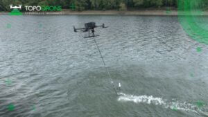
TOPODRONE advances airborne bathymetric surveying with AQUAMAPPER launch at INTERGEO 2022
Montreux, Switzerland – TOPODRONE, a Swiss based designer and manufacturer of high-precision LiDAR equipment for installation on drones, vehicles and backpacks, launches AQUAMAPPER, a UAV-based solution for bathymetric surveying and marine construction.…
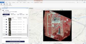
UP42 Launches ArcGIS Pro Add-in as Part of Esri Partner Network
ArcGIS users have direct access to the UP42 platform for easier data visualization and analysis BERLIN, Germany – UP42 made the first major announcement of its new partnership with the introduction of the UP42 ArcGIS Pro Add-in. Available on the Esri…
Emesent launches three time saving products for geospatial professionals
Hovermap ST-X, the newest edition of Emesent’s award-winning Hovermap autonomy and mapping device, captures detailed, accurate data over a greater area in less time. Hovermap ST-X, Long Range Radio, and Emesent’s Aura software platform were…
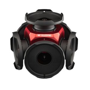
Teledyne announces new Ladybug6 cameras for high accuracy 360-degree spherical image capture
Richmond, CANADA ─ Teledyne FLIR Integrated Imaging Solutions is pleased to announce the all new Ladybug6— the latest addition to its field proven Ladybug series. Ladybug6 is the leading high-resolution camera designed to capture 360-degree spherical…
