

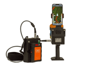
ARIS II Rover Helps Utilities Improve Uptime and Reduce Costs Through Regular Monitoring of Critical, Remote Assets HOLLYWOOD, Fla. – NV5 Geospatial, North America’s most comprehensive geospatial science data firm, today announced the debut…

Shaper Launches Studio – A Simplified Design Tool for Craftspeople
Become a Designer with Just a Few Clicks - Perfect for Laser Cutters, Cricut or CNC Machines San Francisco, Stuttgart, Germany — Shaper…
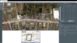
Traffic Design Data Manager from Phocaz Is Powered by the Bentley iTwin Platform
Phocaz’ Traffic Design Data Manager sign assembly checkpoint screen An amazing new application for traffic design engineers—Powered by iTwin!…
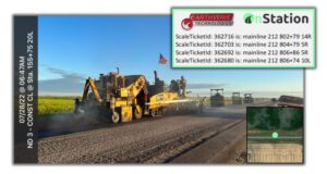
FleetWatcher Partners with OnStation to Pinpoint Location of Each Asphalt Load
(Indianapolis, IN) – Earthwave has integrated their e-ticketing functionality with OnStation to allow users to pinpoint the exact Station Location where each load of asphalt is placed on a jobsite. This new functionality automatically tracks the load…
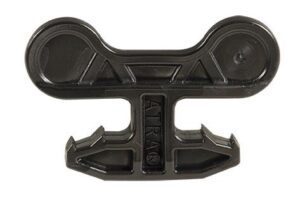
The best geocell connection device on the market just got better
ATRA® Key Connection Device Presto Geosystems, the leader in geocell technology, unveils the new and improved design of the patented ATRA® Key Connection Device for the GEOWEB® Soil Stabilization System (Geocells). The innovative ATRA Key design…

Leica Geosystems Launches New Safety Awareness Module in Leica Conx Cloud Solution
(Heerbrugg, Switzerland, August 23rd, 2022) Leica Geosystems, part of Hexagon, today announced the launch of the new safety awareness module in the cloud-based collaboration platform Leica ConX. The integration of Leica Geosystems’ safety awareness solutions…
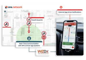
Florida DOT and one.network Launch First-of-its-Kind, Statewide Work Zone Safety Pilot Project
For the first time in the United States, construction crews in work zones will be able to post real-time lane closure information to major GPS providers. TALLAHASSEE, Florida – one.network, an innovative road management software as a service (SaaS)…
GeoSLAM adds real-time data capture feedback to ZEB Horizon
The leading handheld mobile mapping system from GeoSLAM, the ZEB Horizon, is now available with real-time feedback on data capture. The ZEB Horizon RT is compatible with most mobile devices, which attaches to the back of the handheld ZEB…
Trimble RTX Integrity Validates Positioning Data Accuracy to Support Safety-Critical Applications
Providing Even More Reliable Measurements for Users of Trimble CenterPoint RTX Fast Networks in North America and Europe SUNNYVALE, Calif. —Trimble (NASDAQ: TRMB) introduced today data integrity monitoring for its precise point positioning (PPP)…

UP42 Teams Up with Trimble for Faster Information Extraction from Geospatial Data
Automation to Enhance Feature Extraction, Change Detection on the UP42 Platform BERLIN – UP42, a leading geospatial developer platform and marketplace, is collaborating with Trimble to offer automated Trimble® eCognition® software object-based image…
