
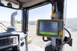
LIVERMORE, Calif. – November 11, 2021 – Topcon Positioning Group has announced its MC-Max machine control solution. Based on its MC-X machine control platform, and backed by Sitelink3D — the company’s real-time, cloud-based data management ecosystem…

SwRI developing connected vehicle data exchange platform for Florida Department of Transportation
Resulting platform will enable real-time, safety-critical data analysis, dissemination Southwest Research Institute is leading an $8 million project to…
Carbon Emissions Insights Tool Will Guide Businesses Toward Net Zero
Normative releases data showing how polluting businesses measure up Startup sets new standard in carbon accounting, automates emission calculations and…
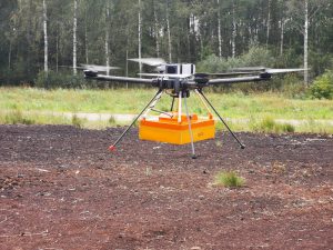
TUNDRA drone integrated with UgCS Integrated Systems solutions
November 3, 2021 (Riga, Latvia) - SPH Engineering and France-based Hexadrone partner to integrate TUNDRA drone with a ground-penetrating radar. The trial flight was conducted in Balogi, Latvia and confirmed the compatibility of the drone with a GPR sensor…

Montana Department of Transportation Transitions to Autodesk Infrastructure Design Solutions Partnering with U.S. CAD for Deployment and Implementation
Adopting Autodesk’s Best-in-class Solutions Paired with U.S. CAD’s Expert Guidance for Professional Services is a Key Part of State’s Digital Delivery Initiative IRVINE, Calif. – U.S. CAD, a leading AEC technology and consulting firm, and Autodesk…
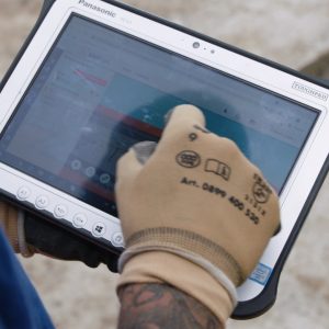
Panasonic TOUGHBOOK Supports Swiss Engineering Company in Move to Paperless Construction Site
KIBAG’s construction workers’ capabilities are transformed with Panasonic Business solutions. BRACKNELL, UK. 26th October 2021 – KIBAG, a Swiss civil engineering company, is taking the final step towards a paperless construction site with the…

City of Cascais Partners With Ubirider to Bring Mobility Innovation to Its Residents
MobiCascais App Allows Residents to Plan and Book Travel, Charge Electric Vehicles, Purchase Tickets for Attractions and Much More to Improve and Enhance Their Mobility Experience PORTO, Portugal, October 26, 2021 - Ubirider, creator of Pick, a digital…

New Integration for Hovermap Data in PointCab Origins Streamlines Point Cloud to Output
A new Emesent - PointCab Origins integration will save users time and improve their outputs. Hovermap, Emesent’s flagship product, is an autonomy and mapping payload capable of capturing high resolution LiDAR data above ground or underground,…

Hexagon Releases Power Portfolio 2022
Latest version empowers users with automated workflows and improved information sharing (HUNTSVILLE, Ala.) – Hexagon’s Safety, Infrastructure & Geospatial division today announced the launch of Power Portfolio 2022, the latest version of its…
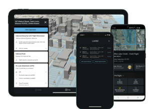
Skyward Integrates Updated LAANC for Night Airspace Access & Refined Grids
Latest generation of FAA’s LAANC introduces authorizations for drone flights at night and refined airspace grids for Skyward customers PORTLAND, Ore. – Skyward, A Verizon company, announced that the next generation of the FAA’s Low…
