
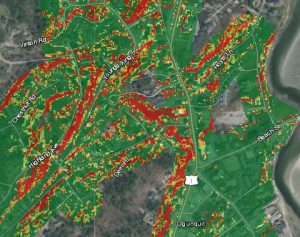
INFRASTRUCTURE PROTECTION TOOL: This screen grab from a new award-winning GZA GeoEnvironmental Inc. GeoTool powered by ArcGIS shows how the software platform can quickly identify “high hazard areas” vulnerable to erosion and landslides. Suitable for use…

Esri Advances ArcGIS Platform
Enhancements to Esri’s Platform as a Service Will Help Developers and Businesses More Efficiently and Securely Build Solutions REDLANDS, Calif.— In…

IGas Energy Video: A Customer Story
IGas is delivering faster time to insight and improving productivity across the enterprise using the ArcGIS platform. A lightweight integrated deployment…
Exprodat Increases Oil & Gas Workflow Integration with Updated Data Assistant
Exprodat, the oil and gas ArcGIS platform specialist, Esri Gold Partner and Getech group company, has released the latest version of its popular Data Assistant software, which simplfies and speeds up the process of importing and exporting common exploration…
Esri Maps NOAA’s National Water Model
New Real-Time Maps Transform Forecast Data into Vivid Pictures of U.S. River Flows REDLANDS, Calif.—August 25, 2016—Smart-mapping leader Esri today released a beautiful, robust new collection of Web maps that forecast NOAA stream-flow data throughout…
