

New Product Connects with Autodesk Construction Cloud to Bridge GIS and BIM REDLANDS, Calif.—October 5, 2021—Global construction challenges, from affordable housing availability to infrastructure stress as a result of climate change, have increased…
Hackers help communities combat effects of dangerous floods at Europe’s biggest hackathon
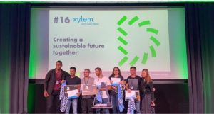
Team “Res-Queue” wins the Xylem Water Challenge award at HackZurich2021 with a decision support system that helps optimize rescue operations during…

Data Science Helps Raleigh Water Avoid Digging Up The Streets
Xylem & Esri Partner to Analyze Risk on 88,000 Pipe Segments And Reduce Planning Time by 75% RYE BROOK, NY, (September 22, 2021) – Global water…

GIS Solutions: Gwinnett County Explores Benefits of Digital Twins at Pump Station
Download the Engineered Solution

Jack Dangermond Honored by IGU with Planet and Humanity Medal
GIS Technology Leader Awarded for Contributions to Global Sustainability REDLANDS, Calif.—May 19, 2021—Esri today announced that the International Geographical Union (IGU) has awarded Jack Dangermond the Planet and Humanity Medal. The award honors…


Video Interviews: 2021 IECA Award Winners
The International Erosion Control Association (IECA) announced winners or a variety of awards during the virtual IECA Annual Conference and Expo held in February 2021. The IECA awards program recognizes outstanding achievements in the erosion and sediment…

EagleView and Esri Canada Announce New Integration Within Cityworks Platform
New integration will make it easier than ever for Cityworks users in Canada to access EagleView's high-resolution aerial imagery BELLEVUE, Wash. and TORONTO, Canada, March 23, 2021 - EagleView, a leading technology provider of aerial imagery and data…

Esri Joins Digital Twin Consortium
Organizations Can Use ArcGIS to Connect Virtual Models, Solving Business Challenges REDLANDS, Calif.— Esri, the global leader in location intelligence, today announced it has joined the Digital Twin Consortium. This authoritative community of users…

Esri Releases ArcGIS Velocity for Analysis of Real-Time IoT Data
Additional License Levels Open Opportunities for New Industries to Integrate Geospatial Sensor Capability REDLANDS, Calif.— Esri, the global leader in location intelligence, today announced the release of ArcGIS Velocity. Previously known as ArcGIS…
