

Esri's 180 Powerful Spatial Analytics Tools and Functions Integrated into the Fabric Platform July 15, 2024 08:00 AM Eastern Daylight Time REDLANDS, Calif.- At its 44th annual User Conference, Esri announced an expanded collaboration with Microsoft to…

Geographic Information Systems Key to Efficient Water Management
The supply of drinking water is one of the greatest challenges currently facing a large part of the world's regions. According to the latest data published…
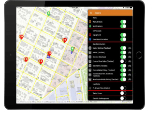
Locana Debuts Winter Release of Lemur, Providing Enhanced Mobile Access to Geospatial Information Systems
Latest Release Features Additional Esri, Salesforce, and iPhone Integration, Security and Support Greenwood Village, Colo. - Locana, an international…

Future Forward: GIS and Digital Twins are Crucial Building Blocks for Renewing U.S. Infrastructure
It’s no longer outside the realm of possibility to see through the ground itself. Augmented reality is bringing utilities and other companies with underground assets closer to realizing that age-old wish via a digital twin of their infrastructure. These…
RMSI partners with Enzen UK to support Scotia Gas Network (SGN), UK for GIS Application Support and Maintenance
San Ramon, CA, US: RMSI, a global leader in geospatial and engineering solutions, has been awarded with a GIS application support and maintenance project for Scotia Gas Network (SGN), UK’s most innovative gas distribution network company. The engagement…

Thermal Imagery for Building and Utilities Owners
By Woolpert’s Qassim Abdullah, Ph.D., PLS, CP and Nadja Turek, PE, F. SAME, LEED AP BD+C, GGP, Envision SP May 2021 Abstract This paper discusses the aerial acquisition of thermal imagery and introduces thermography, acquisition parameters,…

Novara GeoSolutions Awarded the Esri Release Ready Specialty Designation
Norwell, MA. Novara GeoSolutions (Novara) (www.novarageo.com), a multi-disciplined organization providing solutions for asset management, compliance, integrity management, operational improvement and other geospatial needs announces it has been awarded the…

Dewberry Selected to Collect GIS Data for Loudoun Water
Firm will produce record drawings and capture GIS data in Loudoun County, Virginia. Loudoun Water in Loudoun County, Virginia, selected Dewberry to produce record drawings and capture geographic information systems (GIS) data for its potable water, reclaimed…

Esri Honors Architect of the Capitol, Woolpert for Special Achievement in GIS
SAN DIEGO — The Architect of the Capitol (AOC) and Woolpert were awarded Esri’s Special Achievement in GIS (SAG) Award on Wednesday at the 2017 Esri User Conference in San Diego. The team was among 180 selected from more than 300,000 eligible candidates…
Ramboll Honoured with International Award for Special Achievement in Use of Geographic Information (GIS)
Ramboll received the Special Achievement Award (SAG) from Esri, the global American company responsible for the GIS system, for Ramboll’s success in developing and promoting the application of GIS (geographic information system) throughout its business.…
