
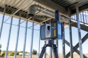
FRANKFURT, Germany — October 7, 2025 — Topcon Positioning Systems announces the expansion of its geomatics portfolio, featuring advancements in mass data software solutions central to a connected workflow ecosystem. The new solutions will be showcased…

Topcon and Amberg Technologies launch integrated solutions for rail and tunnel
FRANKFURT, Germany — Topcon Positioning Systems and Amberg Technologies today announce the companies are entering into a collaboration agreement…

Topcon launches new organization dedicated to Geomatics
LIVERMORE, Calif. — Topcon Positioning Systems today announced the creation of a dedicated business structure focused on delivering high-precision…

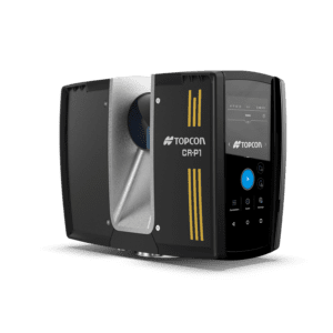
PIX4Dcatch is an integral component of Topcon’s newest handheld scanning solution, the CR-H1, designed for accurate reality capture
Lausanne, April 15, 2025 Pix4D is a core technology collaborator in the newly launched CR-H1 handheld reality capture solution from Topcon Positioning Systems. Pix4D continues to advance its RTK-supported technologies with PIX4Dcatch, now offering compatibility…
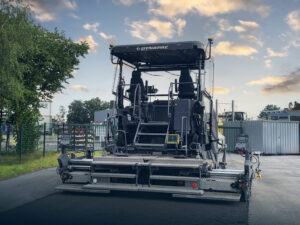
Topcon 3D leveling system now compatible with new Dynapac Highway Paver series
MUNICH — Topcon Positioning Systems has announced that its MC-Max Asphalt paving system has been confirmed compatible with the Dynapac SD25 and XD25 Highway Paver series, enabling automatic control of height, steering, and screed width for enhanced paving…

Topcon launches CR-H1 handheld reality capture solution for maximum mobility
MUNICH — Topcon Positioning Systems has announced the CR-H1, a handheld solution that represents one of the latest additions to the company’s Capture Reality portfolio of mass data solutions. The system utilizes PIX4Dcatch, a specialized application that…
Topcon introduces solutions for 3D mass data workflows
MUNICH — Topcon Positioning Systems has announced new technology solutions for 3D mass data workflows. Enhancements to the Topcon Collage Site software solution provide new workflow capabilities designed to allow for the real-time acquisition and processing…

Topcon and Pix4D collaborate to advance photogrammetry solutions
Topcon Positioning Systems and Pix4D have announced a strategic agreement that combines their expertise in geopositioning and photogrammetry solutions. The collaboration includes Topcon becoming an authorized distributor of Pix4D’s photogrammetry software…

Topcon provides GNSS correction services for emergency response and infrastructure recovery in Southern California
LIVERMORE, Calif. – January 28, 2025 – Topcon Positioning Systems is supporting recovery efforts in Southern California following the recent wildfires by providing emergency Topnet Live subscriptions for access to the company’s global navigation satellite…

Topcon announces landmark expansion of Topnet Live network across USA
LIVERMORE, Calif. — Topcon Positioning Systems has announced a significant expansion of its Topnet Live reference station network, introducing 200 new geodetic stations strategically positioned across the United States. This comprehensive network upgrade…
