
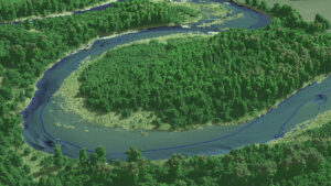
A view looking over the Satsop River in the Chehalis Basin project area. The image was created from the LiDAR bare earth model overlaid with the 3D point cloud and colored by elevation. The project area consists of 8 areas of interest which encompass portions…

UP42 Partners with Nearmap to Offer High-Resolution Aerial Imagery of U.S., Canada, Australia, and New Zealand
“Photo provided by Nearmap” Detail and Refresh Rate Ideal for Utility, AEC, Local Government Monitoring Apps BERLIN– Nearmap’s high-resolution…

UP42 Partners with Intermap to Bring High-Resolution Elevation Data to UP42’s Geospatial Marketplace
NEXTMap Digital Surface Model (DSM) BERLIN, Germany – UP42 is pleased to announce that the NEXTMap Elevation Data Suite from Intermap Technologies…

UP42 Partners With Hexagon To Offer HxGN Content Program Aerial Imagery on Geospatial Marketplace
BERLIN, Germany – High-resolution aerial imagery from the HxGN Content Program is now available on the UP42 developer platform for Earth observation data and analytics. UP42 customers may now choose from nearly 11 million square kilometers of 30 cm orthorectified…
